You are here: Home > Network List > TA - USArray Transportable Network (new EarthScope stations) Stations List
> Station POKR Poker Plat Research Range, AK, USA > Earthquake Result Viewer
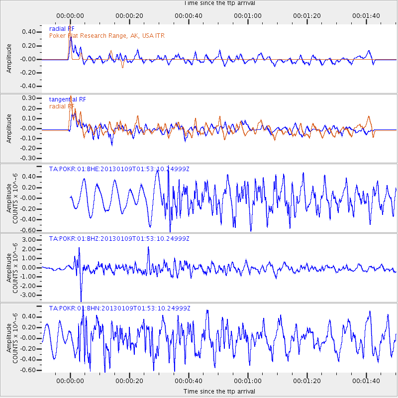
POKR Poker Plat Research Range, AK, USA - Earthquake Result Viewer
*The percent match for this event was below the threshold and hence no stack was calculated.
| Earthquake location: |
Myanmar-India Border Region |
| Earthquake latitude/longitude: |
25.3/95.0 |
| Earthquake time(UTC): |
2013/01/09 (009) 01:41:53 GMT |
| Earthquake Depth: |
93 km |
| Earthquake Magnitude: |
5.8 MB, 5.8 MW, 5.8 MW |
| Earthquake Catalog/Contributor: |
WHDF/NEIC |
|
| Network: |
TA USArray Transportable Network (new EarthScope stations) |
| Station: |
POKR Poker Plat Research Range, AK, USA |
| Lat/Lon: |
65.12 N/147.43 W |
| Elevation: |
501 m |
|
| Distance: |
78.0 deg |
| Az: |
22.561 deg |
| Baz: |
304.851 deg |
| Ray Param: |
$rayparam |
*The percent match for this event was below the threshold and hence was not used in the summary stack. |
|
| Radial Match: |
55.845432 % |
| Radial Bump: |
400 |
| Transverse Match: |
60.002502 % |
| Transverse Bump: |
400 |
| SOD ConfigId: |
493637 |
| Insert Time: |
2013-04-16 13:38:20.366 +0000 |
| GWidth: |
2.5 |
| Max Bumps: |
400 |
| Tol: |
0.001 |
|
Signal To Noise
| Channel | StoN | STA | LTA |
| TA:POKR:01:BHZ:20130109T01:53:10.24999Z | 4.5887184 | 1.0923244E-6 | 2.3804564E-7 |
| TA:POKR:01:BHN:20130109T01:53:10.24999Z | 1.5378898 | 2.479822E-7 | 1.6124835E-7 |
| TA:POKR:01:BHE:20130109T01:53:10.24999Z | 1.6967435 | 3.2102236E-7 | 1.8919911E-7 |
| Arrivals |
| Ps | |
| PpPs | |
| PsPs/PpSs | |


