You are here: Home > Network List > TA - USArray Transportable Network (new EarthScope stations) Stations List
> Station 833A Chaparral WMA, Artesia Wells, TX, USA > Earthquake Result Viewer
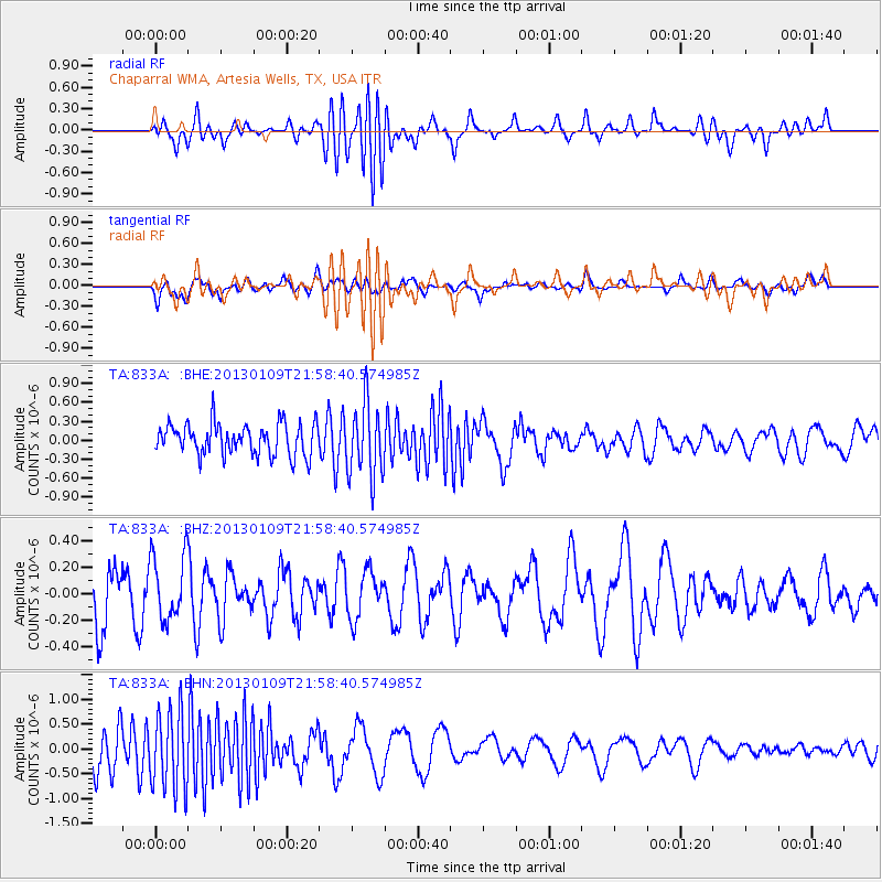
833A Chaparral WMA, Artesia Wells, TX, USA - Earthquake Result Viewer
*The percent match for this event was below the threshold and hence no stack was calculated.
| Earthquake location: |
Pacific-Antarctic Ridge |
| Earthquake latitude/longitude: |
-57.0/-141.5 |
| Earthquake time(UTC): |
2013/01/09 (009) 21:46:02 GMT |
| Earthquake Depth: |
10 km |
| Earthquake Magnitude: |
5.6 MW, 5.0 MS, 5.3 MB, 5.5 MW |
| Earthquake Catalog/Contributor: |
WHDF/NEIC |
|
| Network: |
TA USArray Transportable Network (new EarthScope stations) |
| Station: |
833A Chaparral WMA, Artesia Wells, TX, USA |
| Lat/Lon: |
28.32 N/99.39 W |
| Elevation: |
171 m |
|
| Distance: |
92.2 deg |
| Az: |
36.238 deg |
| Baz: |
201.496 deg |
| Ray Param: |
$rayparam |
*The percent match for this event was below the threshold and hence was not used in the summary stack. |
|
| Radial Match: |
44.38427 % |
| Radial Bump: |
400 |
| Transverse Match: |
54.432816 % |
| Transverse Bump: |
400 |
| SOD ConfigId: |
493637 |
| Insert Time: |
2013-04-16 13:43:57.409 +0000 |
| GWidth: |
2.5 |
| Max Bumps: |
400 |
| Tol: |
0.001 |
|
Signal To Noise
| Channel | StoN | STA | LTA |
| TA:833A: :BHZ:20130109T21:58:40.574985Z | 0.9755582 | 2.5091907E-7 | 2.5720564E-7 |
| TA:833A: :BHN:20130109T21:58:40.574985Z | 2.3220074 | 7.926552E-7 | 3.4136636E-7 |
| TA:833A: :BHE:20130109T21:58:40.574985Z | 2.3430207 | 5.8222844E-7 | 2.4849479E-7 |
| Arrivals |
| Ps | |
| PpPs | |
| PsPs/PpSs | |


