You are here: Home > Network List > G - GEOSCOPE Stations List
> Station TAM Tamanrasset, Algeria > Earthquake Result Viewer
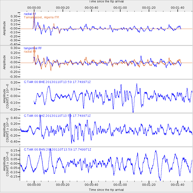
TAM Tamanrasset, Algeria - Earthquake Result Viewer
*The percent match for this event was below the threshold and hence no stack was calculated.
| Earthquake location: |
Northern Sumatra, Indonesia |
| Earthquake latitude/longitude: |
4.7/95.1 |
| Earthquake time(UTC): |
2013/01/10 (010) 13:47:03 GMT |
| Earthquake Depth: |
38 km |
| Earthquake Magnitude: |
5.9 MB, 5.5 MS, 5.7 MW, 5.7 MW |
| Earthquake Catalog/Contributor: |
WHDF/NEIC |
|
| Network: |
G GEOSCOPE |
| Station: |
TAM Tamanrasset, Algeria |
| Lat/Lon: |
22.79 N/5.53 E |
| Elevation: |
1377 m |
|
| Distance: |
87.8 deg |
| Az: |
292.556 deg |
| Baz: |
85.837 deg |
| Ray Param: |
$rayparam |
*The percent match for this event was below the threshold and hence was not used in the summary stack. |
|
| Radial Match: |
70.33946 % |
| Radial Bump: |
400 |
| Transverse Match: |
51.573444 % |
| Transverse Bump: |
373 |
| SOD ConfigId: |
493637 |
| Insert Time: |
2013-04-16 13:48:04.994 +0000 |
| GWidth: |
2.5 |
| Max Bumps: |
400 |
| Tol: |
0.001 |
|
Signal To Noise
| Channel | StoN | STA | LTA |
| G:TAM:00:BHZ:20130110T13:59:17.749971Z | 2.5860312 | 1.7318919E-7 | 6.697103E-8 |
| G:TAM:00:BHN:20130110T13:59:17.749971Z | 0.931463 | 7.338495E-8 | 7.8784616E-8 |
| G:TAM:00:BHE:20130110T13:59:17.749971Z | 1.1632596 | 6.6576575E-8 | 5.7232775E-8 |
| Arrivals |
| Ps | |
| PpPs | |
| PsPs/PpSs | |


