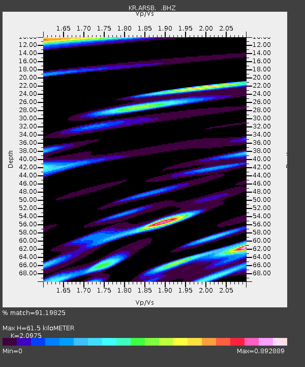
ARSB Arslanbob, Kyrgyzstan - Earthquake Result Viewer

Earthquake location: Northern Sumatra, Indonesia
Earthquake latitude/longitude: 4.7/95.1
Earthquake time(UTC): 2013/01/10 (010) 13:47:03 GMT
Earthquake Depth: 38 km
Earthquake Magnitude: 5.9 MB, 5.5 MS, 5.7 MW, 5.7 MW
Earthquake Catalog/Contributor: WHDF/NEIC
Network: KR Kyrgyz Digital Network
Station: ARSB Arslanbob, Kyrgyzstan
Lat/Lon: 41.33 N/72.97 E
Elevation: 1378 m
Distance: 41.5 deg
Az: 334.649 deg
Baz: 145.485 deg
Ray Param: 0.07367447
Estimated Moho Depth: 61.5 km
Estimated Crust Vp/Vs: 2.10
Assumed Crust Vp: 6.306 km/s
Estimated Crust Vs: 3.006 km/s
Estimated Crust Poisson's Ratio: 0.35
Radial Match: 91.19825 %
Radial Bump: 400
Transverse Match: 83.46182 %
Transverse Bump: 400
SOD ConfigId: 493637
Insert Time: 2013-04-16 13:50:42.854 +0000
GWidth: 2.5
Max Bumps: 400
Tol: 0.001

Signal To Noise

ChannelStoNSTALTA
KR:ARSB: :BHZ:20130110T13:54:16.700013Z20.7004834.082845E-61.9723429E-7
KR:ARSB: :BHN:20130110T13:54:16.700013Z13.2078131.5573049E-61.1790786E-7
KR:ARSB: :BHE:20130110T13:54:16.700013Z6.22445961.020348E-61.6392555E-7
Arrivals
Ps11 SECOND
PpPs29 SECOND
PsPs/PpSs40 SECOND