You are here: Home > Network List > TA - USArray Transportable Network (new EarthScope stations) Stations List
> Station POKR Poker Plat Research Range, AK, USA > Earthquake Result Viewer
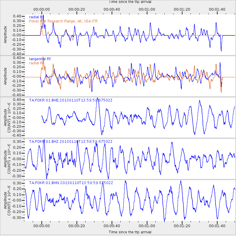
POKR Poker Plat Research Range, AK, USA - Earthquake Result Viewer
*The percent match for this event was below the threshold and hence no stack was calculated.
| Earthquake location: |
Northern Sumatra, Indonesia |
| Earthquake latitude/longitude: |
4.7/95.1 |
| Earthquake time(UTC): |
2013/01/10 (010) 13:47:03 GMT |
| Earthquake Depth: |
38 km |
| Earthquake Magnitude: |
5.9 MB, 5.5 MS, 5.7 MW, 5.7 MW |
| Earthquake Catalog/Contributor: |
WHDF/NEIC |
|
| Network: |
TA USArray Transportable Network (new EarthScope stations) |
| Station: |
POKR Poker Plat Research Range, AK, USA |
| Lat/Lon: |
65.12 N/147.43 W |
| Elevation: |
501 m |
|
| Distance: |
96.9 deg |
| Az: |
22.219 deg |
| Baz: |
297.031 deg |
| Ray Param: |
$rayparam |
*The percent match for this event was below the threshold and hence was not used in the summary stack. |
|
| Radial Match: |
54.307545 % |
| Radial Bump: |
339 |
| Transverse Match: |
46.93162 % |
| Transverse Bump: |
386 |
| SOD ConfigId: |
493637 |
| Insert Time: |
2013-04-16 13:53:52.391 +0000 |
| GWidth: |
2.5 |
| Max Bumps: |
400 |
| Tol: |
0.001 |
|
Signal To Noise
| Channel | StoN | STA | LTA |
| TA:POKR:01:BHZ:20130110T13:59:59.67502Z | 2.376008 | 1.9571176E-7 | 8.236999E-8 |
| TA:POKR:01:BHN:20130110T13:59:59.67502Z | 0.7590075 | 1.128986E-7 | 1.4874503E-7 |
| TA:POKR:01:BHE:20130110T13:59:59.67502Z | 3.0672345 | 2.6496167E-7 | 8.6384546E-8 |
| Arrivals |
| Ps | |
| PpPs | |
| PsPs/PpSs | |


