You are here: Home > Network List > CN - Canadian National Seismograph Network Stations List
> Station INK INUVIK, NT > Earthquake Result Viewer
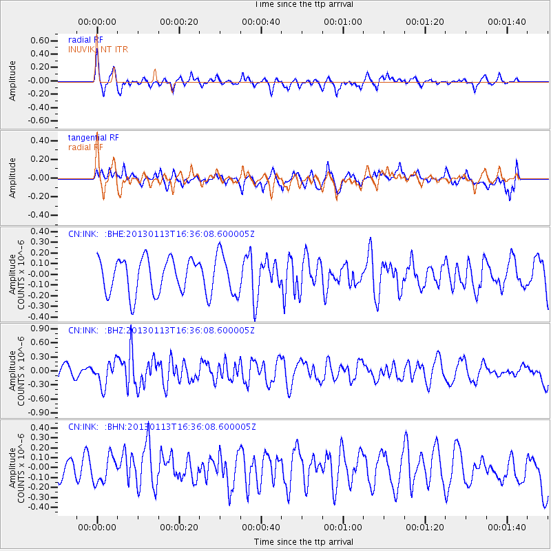
INK INUVIK, NT - Earthquake Result Viewer
*The percent match for this event was below the threshold and hence no stack was calculated.
| Earthquake location: |
Gulf Of California |
| Earthquake latitude/longitude: |
25.9/-110.1 |
| Earthquake time(UTC): |
2013/01/13 (013) 16:28:26 GMT |
| Earthquake Depth: |
10 km |
| Earthquake Magnitude: |
5.5 MB, 5.4 MS, 5.7 MW, 5.5 MW |
| Earthquake Catalog/Contributor: |
WHDF/NEIC |
|
| Network: |
CN Canadian National Seismograph Network |
| Station: |
INK INUVIK, NT |
| Lat/Lon: |
68.31 N/133.53 W |
| Elevation: |
44 m |
|
| Distance: |
44.7 deg |
| Az: |
347.877 deg |
| Baz: |
149.416 deg |
| Ray Param: |
$rayparam |
*The percent match for this event was below the threshold and hence was not used in the summary stack. |
|
| Radial Match: |
64.67716 % |
| Radial Bump: |
400 |
| Transverse Match: |
59.218323 % |
| Transverse Bump: |
400 |
| SOD ConfigId: |
493637 |
| Insert Time: |
2013-04-16 13:57:53.110 +0000 |
| GWidth: |
2.5 |
| Max Bumps: |
400 |
| Tol: |
0.001 |
|
Signal To Noise
| Channel | StoN | STA | LTA |
| CN:INK: :BHZ:20130113T16:36:08.600005Z | 2.249782 | 2.6161825E-7 | 1.16286046E-7 |
| CN:INK: :BHN:20130113T16:36:08.600005Z | 1.144913 | 1.3311441E-7 | 1.1626597E-7 |
| CN:INK: :BHE:20130113T16:36:08.600005Z | 1.2163701 | 1.94178E-7 | 1.5963727E-7 |
| Arrivals |
| Ps | |
| PpPs | |
| PsPs/PpSs | |


