You are here: Home > Network List > TA - USArray Transportable Network (new EarthScope stations) Stations List
> Station J54A Appleton, NY, USA > Earthquake Result Viewer
J54A Appleton, NY, USA - Earthquake Result Viewer
*The percent match for this event was below the threshold and hence no stack was calculated.
| Earthquake location: |
Gulf Of California |
| Earthquake latitude/longitude: |
25.9/-110.1 |
| Earthquake time(UTC): |
2013/01/13 (013) 16:28:26 GMT |
| Earthquake Depth: |
10 km |
| Earthquake Magnitude: |
5.5 MB, 5.4 MS, 5.7 MW, 5.5 MW |
| Earthquake Catalog/Contributor: |
WHDF/NEIC |
|
| Network: |
TA USArray Transportable Network (new EarthScope stations) |
| Station: |
J54A Appleton, NY, USA |
| Lat/Lon: |
43.27 N/78.64 W |
| Elevation: |
112 m |
|
| Distance: |
30.9 deg |
| Az: |
47.882 deg |
| Baz: |
246.177 deg |
| Ray Param: |
$rayparam |
*The percent match for this event was below the threshold and hence was not used in the summary stack. |
|
| Radial Match: |
60.123672 % |
| Radial Bump: |
400 |
| Transverse Match: |
68.765236 % |
| Transverse Bump: |
400 |
| SOD ConfigId: |
493637 |
| Insert Time: |
2013-04-16 14:01:58.413 +0000 |
| GWidth: |
2.5 |
| Max Bumps: |
400 |
| Tol: |
0.001 |
|
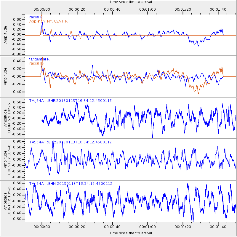
Signal To Noise
| Channel | StoN | STA | LTA |
| TA:J54A: :BHZ:20130113T16:34:12.450011Z | 1.9186018 | 3.8678928E-7 | 2.0159956E-7 |
| TA:J54A: :BHN:20130113T16:34:12.450011Z | 0.8602742 | 1.7372231E-7 | 2.0193829E-7 |
| TA:J54A: :BHE:20130113T16:34:12.450011Z | 2.2360582 | 3.8988273E-7 | 1.7436162E-7 |
| Arrivals |
| Ps | |
| PpPs | |
| PsPs/PpSs | |


