You are here: Home > Network List > TA - USArray Transportable Network (new EarthScope stations) Stations List
> Station U41A Viola, AR, USA > Earthquake Result Viewer
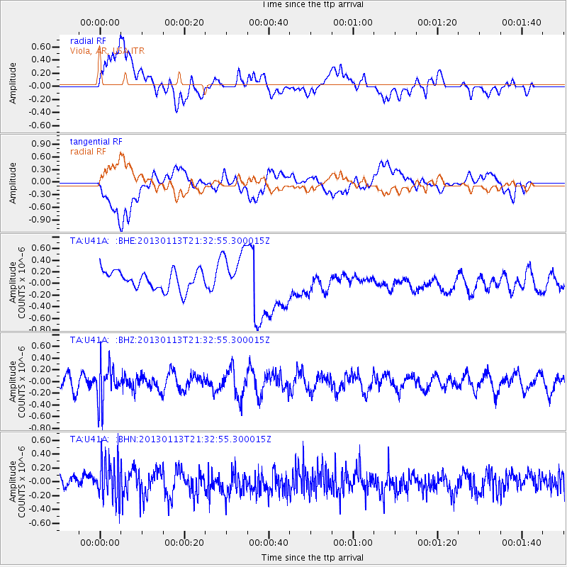
U41A Viola, AR, USA - Earthquake Result Viewer
*The percent match for this event was below the threshold and hence no stack was calculated.
| Earthquake location: |
Northern Chile |
| Earthquake latitude/longitude: |
-20.1/-69.0 |
| Earthquake time(UTC): |
2013/01/13 (013) 21:23:26 GMT |
| Earthquake Depth: |
75 km |
| Earthquake Magnitude: |
5.5 MB, 5.3 MW, 5.3 MW |
| Earthquake Catalog/Contributor: |
WHDF/NEIC |
|
| Network: |
TA USArray Transportable Network (new EarthScope stations) |
| Station: |
U41A Viola, AR, USA |
| Lat/Lon: |
36.34 N/91.92 W |
| Elevation: |
300 m |
|
| Distance: |
60.1 deg |
| Az: |
338.784 deg |
| Baz: |
155.078 deg |
| Ray Param: |
$rayparam |
*The percent match for this event was below the threshold and hence was not used in the summary stack. |
|
| Radial Match: |
39.787086 % |
| Radial Bump: |
400 |
| Transverse Match: |
32.241238 % |
| Transverse Bump: |
400 |
| SOD ConfigId: |
493637 |
| Insert Time: |
2013-04-16 14:22:31.683 +0000 |
| GWidth: |
2.5 |
| Max Bumps: |
400 |
| Tol: |
0.001 |
|
Signal To Noise
| Channel | StoN | STA | LTA |
| TA:U41A: :BHZ:20130113T21:32:55.300015Z | 2.7832882 | 3.202451E-7 | 1.1505998E-7 |
| TA:U41A: :BHN:20130113T21:32:55.300015Z | 2.3612444 | 2.9607858E-7 | 1.2539091E-7 |
| TA:U41A: :BHE:20130113T21:32:55.300015Z | 2.4361641 | 3.8577514E-7 | 1.583535E-7 |
| Arrivals |
| Ps | |
| PpPs | |
| PsPs/PpSs | |


