You are here: Home > Network List > NL - Netherlands Seismic Network Stations List
> Station HGN NL.HGN > Earthquake Result Viewer
HGN NL.HGN - Earthquake Result Viewer

| Earthquake location: |
Lake Tanganyika Region |
| Earthquake latitude/longitude: |
-6.2/29.8 |
| Earthquake time(UTC): |
2005/12/05 (339) 12:19:56 GMT |
| Earthquake Depth: |
22 km |
| Earthquake Magnitude: |
6.4 MB, 7.2 MS, 6.8 MW, 6.7 MW |
| Earthquake Catalog/Contributor: |
WHDF/NEIC |
|
| Network: |
NL Netherlands Seismic Network |
| Station: |
HGN NL.HGN |
| Lat/Lon: |
50.76 N/5.93 E |
| Elevation: |
135 m |
|
| Distance: |
60.4 deg |
| Az: |
342.788 deg |
| Baz: |
152.404 deg |
| Ray Param: |
0.0615341 |
| Estimated Moho Depth: |
33.5 km |
| Estimated Crust Vp/Vs: |
1.70 |
| Assumed Crust Vp: |
6.276 km/s |
| Estimated Crust Vs: |
3.697 km/s |
| Estimated Crust Poisson's Ratio: |
0.23 |
|
| Radial Match: |
96.37055 % |
| Radial Bump: |
400 |
| Transverse Match: |
82.981094 % |
| Transverse Bump: |
400 |
| SOD ConfigId: |
2422 |
| Insert Time: |
2010-02-27 01:31:07.303 +0000 |
| GWidth: |
2.5 |
| Max Bumps: |
400 |
| Tol: |
0.001 |
|
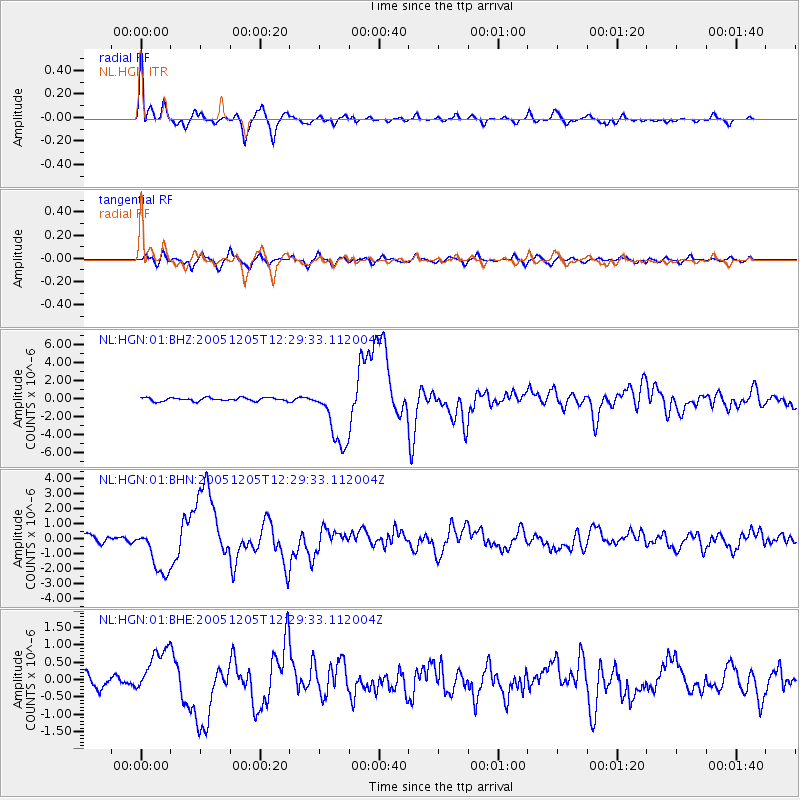
Signal To Noise
| Channel | StoN | STA | LTA |
| NL:HGN:01:BHN:20051205T12:29:33.112004Z | 7.0107203 | 1.5469623E-6 | 2.2065669E-7 |
| NL:HGN:01:BHE:20051205T12:29:33.112004Z | 3.8590968 | 6.763858E-7 | 1.752705E-7 |
| NL:HGN:01:BHZ:20051205T12:29:33.112004Z | 18.606907 | 3.5530736E-6 | 1.9095454E-7 |
| Arrivals |
| Ps | 3.9 SECOND |
| PpPs | 14 SECOND |
| PsPs/PpSs | 18 SECOND |


