You are here: Home > Network List > TA - USArray Transportable Network (new EarthScope stations) Stations List
> Station G41A Antigo, WI, USA > Earthquake Result Viewer
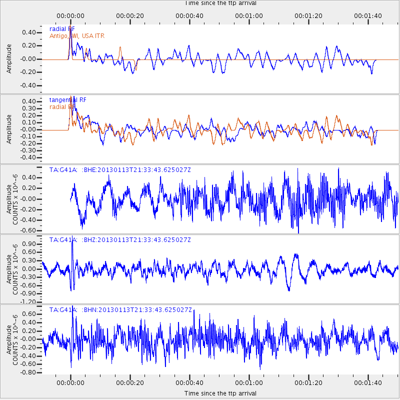
G41A Antigo, WI, USA - Earthquake Result Viewer
*The percent match for this event was below the threshold and hence no stack was calculated.
| Earthquake location: |
Northern Chile |
| Earthquake latitude/longitude: |
-20.1/-69.0 |
| Earthquake time(UTC): |
2013/01/13 (013) 21:23:26 GMT |
| Earthquake Depth: |
75 km |
| Earthquake Magnitude: |
5.5 MB, 5.3 MW, 5.3 MW |
| Earthquake Catalog/Contributor: |
WHDF/NEIC |
|
| Network: |
TA USArray Transportable Network (new EarthScope stations) |
| Station: |
G41A Antigo, WI, USA |
| Lat/Lon: |
45.21 N/89.18 W |
| Elevation: |
464 m |
|
| Distance: |
67.5 deg |
| Az: |
344.731 deg |
| Baz: |
159.498 deg |
| Ray Param: |
$rayparam |
*The percent match for this event was below the threshold and hence was not used in the summary stack. |
|
| Radial Match: |
54.408474 % |
| Radial Bump: |
400 |
| Transverse Match: |
62.65375 % |
| Transverse Bump: |
400 |
| SOD ConfigId: |
493637 |
| Insert Time: |
2013-04-16 14:26:34.431 +0000 |
| GWidth: |
2.5 |
| Max Bumps: |
400 |
| Tol: |
0.001 |
|
Signal To Noise
| Channel | StoN | STA | LTA |
| TA:G41A: :BHZ:20130113T21:33:43.625027Z | 2.1711395 | 3.6466878E-7 | 1.6796193E-7 |
| TA:G41A: :BHN:20130113T21:33:43.625027Z | 1.6352841 | 2.874831E-7 | 1.758001E-7 |
| TA:G41A: :BHE:20130113T21:33:43.625027Z | 0.90564597 | 1.7288359E-7 | 1.9089532E-7 |
| Arrivals |
| Ps | |
| PpPs | |
| PsPs/PpSs | |


