You are here: Home > Network List > TA - USArray Transportable Network (new EarthScope stations) Stations List
> Station 121A Cookes Peak, Deming, NM, USA > Earthquake Result Viewer
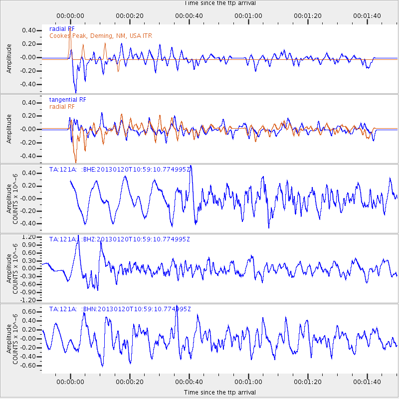
121A Cookes Peak, Deming, NM, USA - Earthquake Result Viewer
*The percent match for this event was below the threshold and hence no stack was calculated.
| Earthquake location: |
Eastern Siberia, Russia |
| Earthquake latitude/longitude: |
64.8/146.5 |
| Earthquake time(UTC): |
2013/01/20 (020) 10:48:47 GMT |
| Earthquake Depth: |
12 km |
| Earthquake Magnitude: |
5.7 MB, 5.5 MS, 5.5 MW, 5.6 MW |
| Earthquake Catalog/Contributor: |
WHDF/NEIC |
|
| Network: |
TA USArray Transportable Network (new EarthScope stations) |
| Station: |
121A Cookes Peak, Deming, NM, USA |
| Lat/Lon: |
32.53 N/107.79 W |
| Elevation: |
1652 m |
|
| Distance: |
67.3 deg |
| Az: |
61.823 deg |
| Baz: |
333.506 deg |
| Ray Param: |
$rayparam |
*The percent match for this event was below the threshold and hence was not used in the summary stack. |
|
| Radial Match: |
60.89403 % |
| Radial Bump: |
400 |
| Transverse Match: |
59.119446 % |
| Transverse Bump: |
400 |
| SOD ConfigId: |
494114 |
| Insert Time: |
2013-04-21 00:28:34.664 +0000 |
| GWidth: |
2.5 |
| Max Bumps: |
400 |
| Tol: |
0.001 |
|
Signal To Noise
| Channel | StoN | STA | LTA |
| TA:121A: :BHZ:20130120T10:59:10.774995Z | 2.477737 | 5.486283E-7 | 2.2142314E-7 |
| TA:121A: :BHN:20130120T10:59:10.774995Z | 1.3198197 | 2.592856E-7 | 1.9645533E-7 |
| TA:121A: :BHE:20130120T10:59:10.774995Z | 1.014591 | 2.033084E-7 | 2.003846E-7 |
| Arrivals |
| Ps | |
| PpPs | |
| PsPs/PpSs | |


