You are here: Home > Network List > TA - USArray Transportable Network (new EarthScope stations) Stations List
> Station X50B Fort Payne, AL, USA > Earthquake Result Viewer
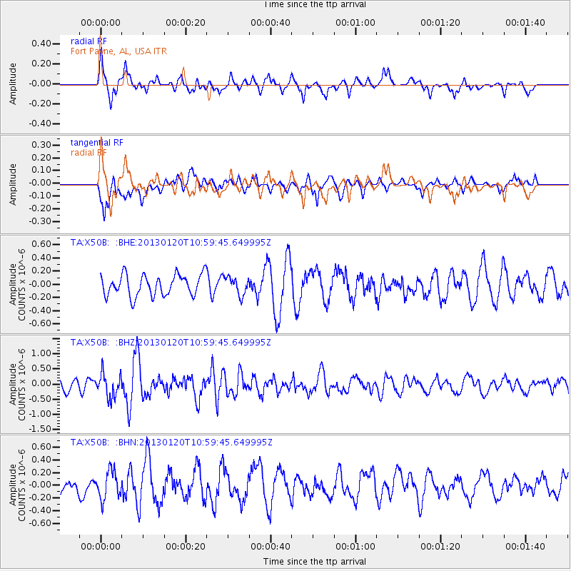
X50B Fort Payne, AL, USA - Earthquake Result Viewer
*The percent match for this event was below the threshold and hence no stack was calculated.
| Earthquake location: |
Eastern Siberia, Russia |
| Earthquake latitude/longitude: |
64.8/146.5 |
| Earthquake time(UTC): |
2013/01/20 (020) 10:48:47 GMT |
| Earthquake Depth: |
12 km |
| Earthquake Magnitude: |
5.7 MB, 5.5 MS, 5.5 MW, 5.6 MW |
| Earthquake Catalog/Contributor: |
WHDF/NEIC |
|
| Network: |
TA USArray Transportable Network (new EarthScope stations) |
| Station: |
X50B Fort Payne, AL, USA |
| Lat/Lon: |
34.46 N/85.65 W |
| Elevation: |
494 m |
|
| Distance: |
73.0 deg |
| Az: |
43.024 deg |
| Baz: |
339.329 deg |
| Ray Param: |
$rayparam |
*The percent match for this event was below the threshold and hence was not used in the summary stack. |
|
| Radial Match: |
69.361046 % |
| Radial Bump: |
400 |
| Transverse Match: |
58.14382 % |
| Transverse Bump: |
400 |
| SOD ConfigId: |
494114 |
| Insert Time: |
2013-04-21 00:32:38.677 +0000 |
| GWidth: |
2.5 |
| Max Bumps: |
400 |
| Tol: |
0.001 |
|
Signal To Noise
| Channel | StoN | STA | LTA |
| TA:X50B: :BHZ:20130120T10:59:45.649995Z | 2.017336 | 3.9887252E-7 | 1.9772241E-7 |
| TA:X50B: :BHN:20130120T10:59:45.649995Z | 1.3757728 | 2.2308366E-7 | 1.6215152E-7 |
| TA:X50B: :BHE:20130120T10:59:45.649995Z | 0.82686895 | 1.3244393E-7 | 1.6017525E-7 |
| Arrivals |
| Ps | |
| PpPs | |
| PsPs/PpSs | |


