You are here: Home > Network List > TA - USArray Transportable Network (new EarthScope stations) Stations List
> Station W47A Westpoint, TN, USA > Earthquake Result Viewer
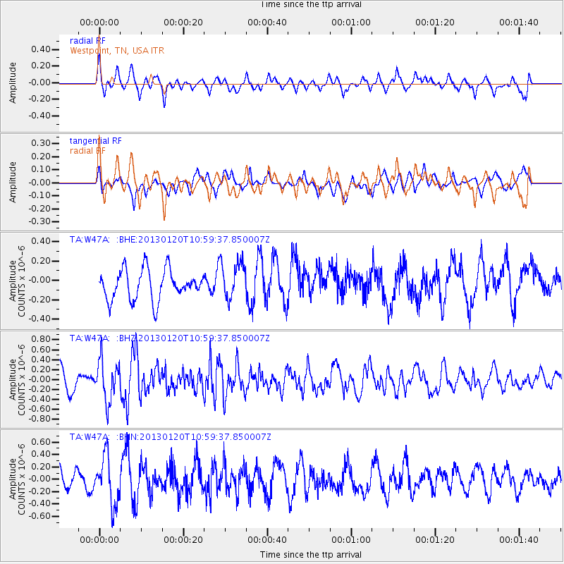
W47A Westpoint, TN, USA - Earthquake Result Viewer
*The percent match for this event was below the threshold and hence no stack was calculated.
| Earthquake location: |
Eastern Siberia, Russia |
| Earthquake latitude/longitude: |
64.8/146.5 |
| Earthquake time(UTC): |
2013/01/20 (020) 10:48:47 GMT |
| Earthquake Depth: |
12 km |
| Earthquake Magnitude: |
5.7 MB, 5.5 MS, 5.5 MW, 5.6 MW |
| Earthquake Catalog/Contributor: |
WHDF/NEIC |
|
| Network: |
TA USArray Transportable Network (new EarthScope stations) |
| Station: |
W47A Westpoint, TN, USA |
| Lat/Lon: |
35.25 N/87.59 W |
| Elevation: |
293 m |
|
| Distance: |
71.7 deg |
| Az: |
44.294 deg |
| Baz: |
338.608 deg |
| Ray Param: |
$rayparam |
*The percent match for this event was below the threshold and hence was not used in the summary stack. |
|
| Radial Match: |
62.141888 % |
| Radial Bump: |
400 |
| Transverse Match: |
54.52223 % |
| Transverse Bump: |
400 |
| SOD ConfigId: |
494114 |
| Insert Time: |
2013-04-21 00:33:03.512 +0000 |
| GWidth: |
2.5 |
| Max Bumps: |
400 |
| Tol: |
0.001 |
|
Signal To Noise
| Channel | StoN | STA | LTA |
| TA:W47A: :BHZ:20130120T10:59:37.850007Z | 2.103914 | 4.14876E-7 | 1.9719249E-7 |
| TA:W47A: :BHN:20130120T10:59:37.850007Z | 2.2825327 | 3.9523292E-7 | 1.7315543E-7 |
| TA:W47A: :BHE:20130120T10:59:37.850007Z | 1.2219517 | 1.8903727E-7 | 1.5470108E-7 |
| Arrivals |
| Ps | |
| PpPs | |
| PsPs/PpSs | |


