You are here: Home > Network List > US - United States National Seismic Network Stations List
> Station HAWA Hanford, Washington, USA > Earthquake Result Viewer
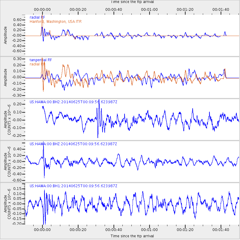
HAWA Hanford, Washington, USA - Earthquake Result Viewer
*The percent match for this event was below the threshold and hence no stack was calculated.
| Earthquake location: |
Rat Islands, Aleutian Islands |
| Earthquake latitude/longitude: |
52.0/178.5 |
| Earthquake time(UTC): |
2014/06/25 (176) 00:03:05 GMT |
| Earthquake Depth: |
116 km |
| Earthquake Magnitude: |
5.1 MW |
| Earthquake Catalog/Contributor: |
ISC/ISC |
|
| Network: |
US United States National Seismic Network |
| Station: |
HAWA Hanford, Washington, USA |
| Lat/Lon: |
46.39 N/119.53 W |
| Elevation: |
364 m |
|
| Distance: |
39.8 deg |
| Az: |
72.649 deg |
| Baz: |
301.45 deg |
| Ray Param: |
$rayparam |
*The percent match for this event was below the threshold and hence was not used in the summary stack. |
|
| Radial Match: |
44.13206 % |
| Radial Bump: |
400 |
| Transverse Match: |
50.3076 % |
| Transverse Bump: |
400 |
| SOD ConfigId: |
3390531 |
| Insert Time: |
2019-04-12 13:12:46.026 +0000 |
| GWidth: |
2.5 |
| Max Bumps: |
400 |
| Tol: |
0.001 |
|
Signal To Noise
| Channel | StoN | STA | LTA |
| US:HAWA:00:BHZ:20140625T00:09:56.623987Z | 2.0223072 | 1.9435818E-7 | 9.610715E-8 |
| US:HAWA:00:BH1:20140625T00:09:56.623987Z | 1.3905934 | 8.207876E-8 | 5.9024273E-8 |
| US:HAWA:00:BH2:20140625T00:09:56.623987Z | 1.703203 | 1.048472E-7 | 6.155884E-8 |
| Arrivals |
| Ps | |
| PpPs | |
| PsPs/PpSs | |


