You are here: Home > Network List > CI - Caltech Regional Seismic Network Stations List
> Station MPM Manuel Prospect Mine, California, USA > Earthquake Result Viewer
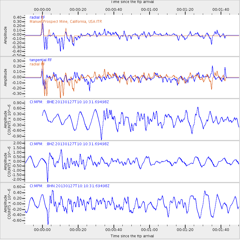
MPM Manuel Prospect Mine, California, USA - Earthquake Result Viewer
*The percent match for this event was below the threshold and hence no stack was calculated.
| Earthquake location: |
Tonga Islands |
| Earthquake latitude/longitude: |
-16.1/-173.2 |
| Earthquake time(UTC): |
2013/01/27 (027) 09:59:29 GMT |
| Earthquake Depth: |
19 km |
| Earthquake Magnitude: |
5.7 MB, 5.5 MS, 5.7 MW, 5.7 MW |
| Earthquake Catalog/Contributor: |
WHDF/NEIC |
|
| Network: |
CI Caltech Regional Seismic Network |
| Station: |
MPM Manuel Prospect Mine, California, USA |
| Lat/Lon: |
36.06 N/117.49 W |
| Elevation: |
185 m |
|
| Distance: |
73.9 deg |
| Az: |
44.184 deg |
| Baz: |
235.767 deg |
| Ray Param: |
$rayparam |
*The percent match for this event was below the threshold and hence was not used in the summary stack. |
|
| Radial Match: |
78.6498 % |
| Radial Bump: |
400 |
| Transverse Match: |
55.994286 % |
| Transverse Bump: |
400 |
| SOD ConfigId: |
494114 |
| Insert Time: |
2013-04-24 03:38:54.224 +0000 |
| GWidth: |
2.5 |
| Max Bumps: |
400 |
| Tol: |
0.001 |
|
Signal To Noise
| Channel | StoN | STA | LTA |
| CI:MPM: :BHZ:20130127T10:10:31.69498Z | 2.1791854 | 7.610717E-7 | 3.4924594E-7 |
| CI:MPM: :BHN:20130127T10:10:31.69498Z | 1.1330822 | 3.0761538E-7 | 2.714855E-7 |
| CI:MPM: :BHE:20130127T10:10:31.69498Z | 1.8547126 | 4.9571577E-7 | 2.6727363E-7 |
| Arrivals |
| Ps | |
| PpPs | |
| PsPs/PpSs | |


