You are here: Home > Network List > IW - Intermountain West Stations List
> Station IMW Indian Meadow, Wyoming, USA > Earthquake Result Viewer
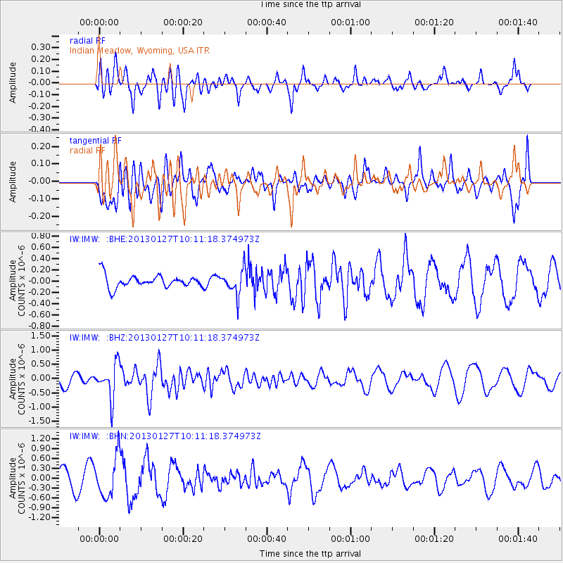
IMW Indian Meadow, Wyoming, USA - Earthquake Result Viewer
*The percent match for this event was below the threshold and hence no stack was calculated.
| Earthquake location: |
Tonga Islands |
| Earthquake latitude/longitude: |
-16.1/-173.2 |
| Earthquake time(UTC): |
2013/01/27 (027) 09:59:29 GMT |
| Earthquake Depth: |
19 km |
| Earthquake Magnitude: |
5.7 MB, 5.5 MS, 5.7 MW, 5.7 MW |
| Earthquake Catalog/Contributor: |
WHDF/NEIC |
|
| Network: |
IW Intermountain West |
| Station: |
IMW Indian Meadow, Wyoming, USA |
| Lat/Lon: |
43.90 N/110.94 W |
| Elevation: |
2646 m |
|
| Distance: |
82.4 deg |
| Az: |
40.22 deg |
| Baz: |
239.155 deg |
| Ray Param: |
$rayparam |
*The percent match for this event was below the threshold and hence was not used in the summary stack. |
|
| Radial Match: |
48.150387 % |
| Radial Bump: |
391 |
| Transverse Match: |
44.485775 % |
| Transverse Bump: |
400 |
| SOD ConfigId: |
494114 |
| Insert Time: |
2013-04-24 03:42:23.377 +0000 |
| GWidth: |
2.5 |
| Max Bumps: |
400 |
| Tol: |
0.001 |
|
Signal To Noise
| Channel | StoN | STA | LTA |
| IW:IMW: :BHZ:20130127T10:11:18.374973Z | 2.715162 | 6.173513E-7 | 2.2737179E-7 |
| IW:IMW: :BHN:20130127T10:11:18.374973Z | 1.8133229 | 6.137036E-7 | 3.3844142E-7 |
| IW:IMW: :BHE:20130127T10:11:18.374973Z | 2.0351615 | 2.2656315E-7 | 1.1132441E-7 |
| Arrivals |
| Ps | |
| PpPs | |
| PsPs/PpSs | |


