You are here: Home > Network List > IW - Intermountain West Stations List
> Station DLMT Dillon, Montana, USA > Earthquake Result Viewer
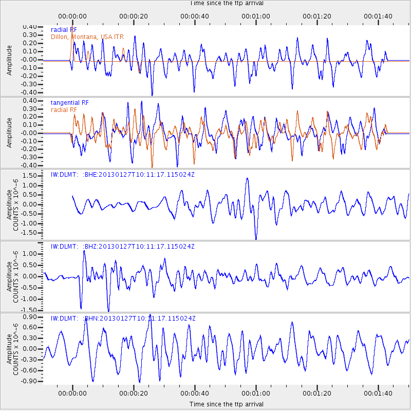
DLMT Dillon, Montana, USA - Earthquake Result Viewer
*The percent match for this event was below the threshold and hence no stack was calculated.
| Earthquake location: |
Tonga Islands |
| Earthquake latitude/longitude: |
-16.1/-173.2 |
| Earthquake time(UTC): |
2013/01/27 (027) 09:59:29 GMT |
| Earthquake Depth: |
19 km |
| Earthquake Magnitude: |
5.7 MB, 5.5 MS, 5.7 MW, 5.7 MW |
| Earthquake Catalog/Contributor: |
WHDF/NEIC |
|
| Network: |
IW Intermountain West |
| Station: |
DLMT Dillon, Montana, USA |
| Lat/Lon: |
45.36 N/112.60 W |
| Elevation: |
1569 m |
|
| Distance: |
82.1 deg |
| Az: |
38.335 deg |
| Baz: |
237.741 deg |
| Ray Param: |
$rayparam |
*The percent match for this event was below the threshold and hence was not used in the summary stack. |
|
| Radial Match: |
62.792248 % |
| Radial Bump: |
400 |
| Transverse Match: |
56.17112 % |
| Transverse Bump: |
400 |
| SOD ConfigId: |
494114 |
| Insert Time: |
2013-04-24 03:42:44.285 +0000 |
| GWidth: |
2.5 |
| Max Bumps: |
400 |
| Tol: |
0.001 |
|
Signal To Noise
| Channel | StoN | STA | LTA |
| IW:DLMT: :BHZ:20130127T10:11:17.115024Z | 2.7006283 | 5.742942E-7 | 2.1265205E-7 |
| IW:DLMT: :BHN:20130127T10:11:17.115024Z | 1.2454278 | 4.0285826E-7 | 3.2346978E-7 |
| IW:DLMT: :BHE:20130127T10:11:17.115024Z | 1.9918622 | 3.8298393E-7 | 1.9227431E-7 |
| Arrivals |
| Ps | |
| PpPs | |
| PsPs/PpSs | |


