You are here: Home > Network List > TA - USArray Transportable Network (new EarthScope stations) Stations List
> Station 121A Cookes Peak, Deming, NM, USA > Earthquake Result Viewer
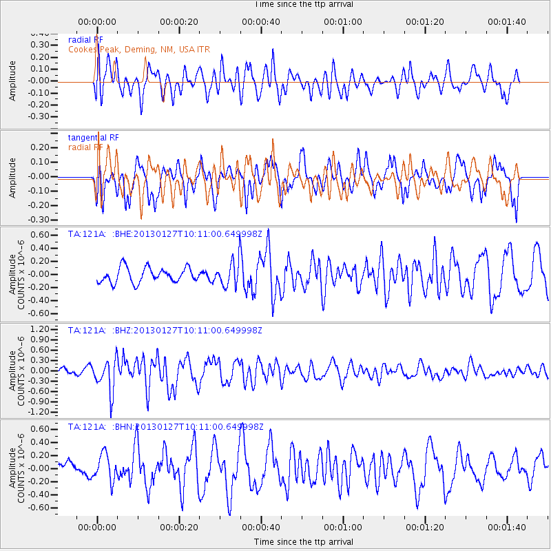
121A Cookes Peak, Deming, NM, USA - Earthquake Result Viewer
*The percent match for this event was below the threshold and hence no stack was calculated.
| Earthquake location: |
Tonga Islands |
| Earthquake latitude/longitude: |
-16.1/-173.2 |
| Earthquake time(UTC): |
2013/01/27 (027) 09:59:29 GMT |
| Earthquake Depth: |
19 km |
| Earthquake Magnitude: |
5.7 MB, 5.5 MS, 5.7 MW, 5.7 MW |
| Earthquake Catalog/Contributor: |
WHDF/NEIC |
|
| Network: |
TA USArray Transportable Network (new EarthScope stations) |
| Station: |
121A Cookes Peak, Deming, NM, USA |
| Lat/Lon: |
32.53 N/107.79 W |
| Elevation: |
1652 m |
|
| Distance: |
79.1 deg |
| Az: |
51.496 deg |
| Baz: |
242.932 deg |
| Ray Param: |
$rayparam |
*The percent match for this event was below the threshold and hence was not used in the summary stack. |
|
| Radial Match: |
64.0607 % |
| Radial Bump: |
400 |
| Transverse Match: |
56.6822 % |
| Transverse Bump: |
373 |
| SOD ConfigId: |
494114 |
| Insert Time: |
2013-04-24 03:44:53.564 +0000 |
| GWidth: |
2.5 |
| Max Bumps: |
400 |
| Tol: |
0.001 |
|
Signal To Noise
| Channel | StoN | STA | LTA |
| TA:121A: :BHZ:20130127T10:11:00.649998Z | 2.6364098 | 4.8456343E-7 | 1.8379671E-7 |
| TA:121A: :BHN:20130127T10:11:00.649998Z | 0.8038066 | 2.0919316E-7 | 2.6025307E-7 |
| TA:121A: :BHE:20130127T10:11:00.649998Z | 1.8205321 | 2.0695626E-7 | 1.1367899E-7 |
| Arrivals |
| Ps | |
| PpPs | |
| PsPs/PpSs | |


