You are here: Home > Network List > TA - USArray Transportable Network (new EarthScope stations) Stations List
> Station Q41A Truxton, MO, USA > Earthquake Result Viewer
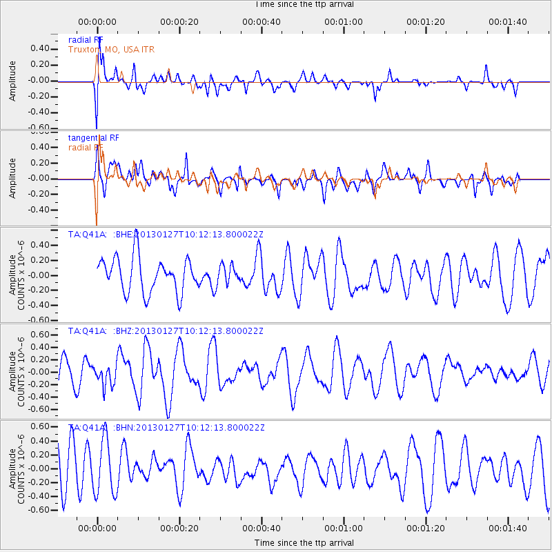
Q41A Truxton, MO, USA - Earthquake Result Viewer
*The percent match for this event was below the threshold and hence no stack was calculated.
| Earthquake location: |
Tonga Islands |
| Earthquake latitude/longitude: |
-16.1/-173.2 |
| Earthquake time(UTC): |
2013/01/27 (027) 09:59:29 GMT |
| Earthquake Depth: |
19 km |
| Earthquake Magnitude: |
5.7 MB, 5.5 MS, 5.7 MW, 5.7 MW |
| Earthquake Catalog/Contributor: |
WHDF/NEIC |
|
| Network: |
TA USArray Transportable Network (new EarthScope stations) |
| Station: |
Q41A Truxton, MO, USA |
| Lat/Lon: |
38.95 N/91.23 W |
| Elevation: |
191 m |
|
| Distance: |
93.9 deg |
| Az: |
50.71 deg |
| Baz: |
252.57 deg |
| Ray Param: |
$rayparam |
*The percent match for this event was below the threshold and hence was not used in the summary stack. |
|
| Radial Match: |
62.72364 % |
| Radial Bump: |
400 |
| Transverse Match: |
54.30641 % |
| Transverse Bump: |
400 |
| SOD ConfigId: |
494114 |
| Insert Time: |
2013-04-24 03:47:24.497 +0000 |
| GWidth: |
2.5 |
| Max Bumps: |
400 |
| Tol: |
0.001 |
|
Signal To Noise
| Channel | StoN | STA | LTA |
| TA:Q41A: :BHZ:20130127T10:12:13.800022Z | 0.63014734 | 1.7453532E-7 | 2.769754E-7 |
| TA:Q41A: :BHN:20130127T10:12:13.800022Z | 1.4387109 | 4.09271E-7 | 2.8447062E-7 |
| TA:Q41A: :BHE:20130127T10:12:13.800022Z | 0.50001025 | 1.15669735E-7 | 2.3133472E-7 |
| Arrivals |
| Ps | |
| PpPs | |
| PsPs/PpSs | |


