You are here: Home > Network List > UW - Pacific Northwest Regional Seismic Network Stations List
> Station MRBL Marblemount, WA, USA > Earthquake Result Viewer
MRBL Marblemount, WA, USA - Earthquake Result Viewer
*The percent match for this event was below the threshold and hence no stack was calculated.
| Earthquake location: |
Tonga Islands |
| Earthquake latitude/longitude: |
-16.1/-173.2 |
| Earthquake time(UTC): |
2013/01/27 (027) 09:59:29 GMT |
| Earthquake Depth: |
19 km |
| Earthquake Magnitude: |
5.7 MB, 5.5 MS, 5.7 MW, 5.7 MW |
| Earthquake Catalog/Contributor: |
WHDF/NEIC |
|
| Network: |
UW Pacific Northwest Regional Seismic Network |
| Station: |
MRBL Marblemount, WA, USA |
| Lat/Lon: |
48.52 N/121.48 W |
| Elevation: |
75 m |
|
| Distance: |
79.1 deg |
| Az: |
32.126 deg |
| Baz: |
230.245 deg |
| Ray Param: |
$rayparam |
*The percent match for this event was below the threshold and hence was not used in the summary stack. |
|
| Radial Match: |
52.324078 % |
| Radial Bump: |
400 |
| Transverse Match: |
54.22121 % |
| Transverse Bump: |
400 |
| SOD ConfigId: |
494114 |
| Insert Time: |
2013-04-24 03:49:18.306 +0000 |
| GWidth: |
2.5 |
| Max Bumps: |
400 |
| Tol: |
0.001 |
|
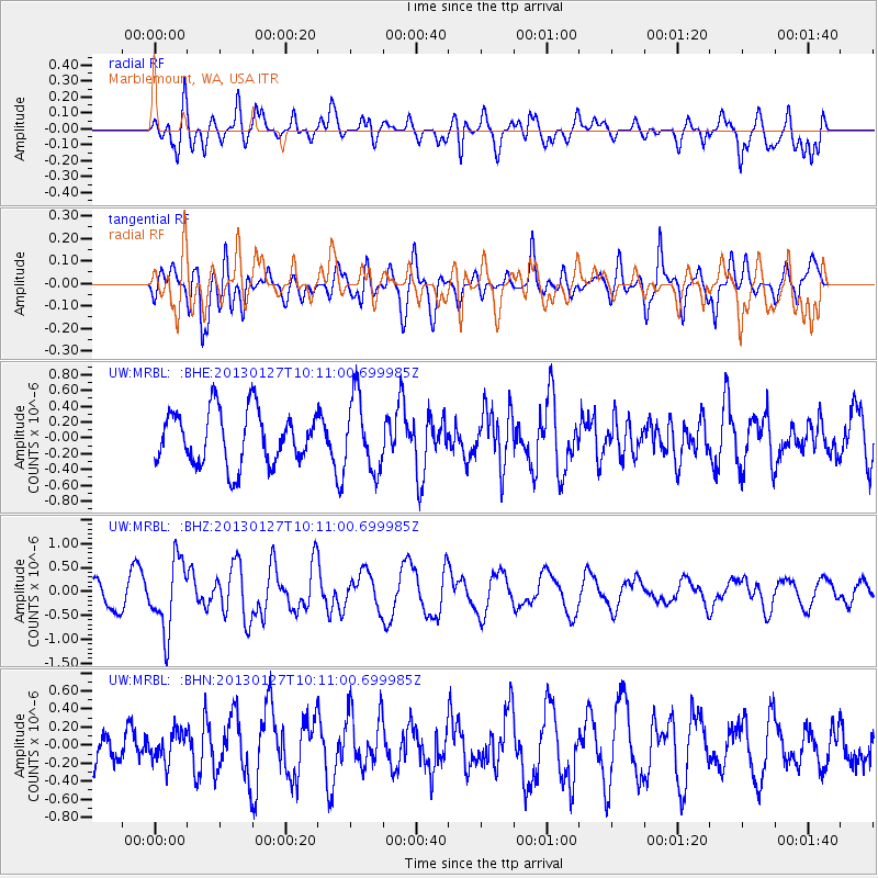
Signal To Noise
| Channel | StoN | STA | LTA |
| UW:MRBL: :BHZ:20130127T10:11:00.699985Z | 2.1594825 | 7.3139165E-7 | 3.3868835E-7 |
| UW:MRBL: :BHN:20130127T10:11:00.699985Z | 0.47772413 | 1.6592625E-7 | 3.473265E-7 |
| UW:MRBL: :BHE:20130127T10:11:00.699985Z | 1.3569639 | 4.5967025E-7 | 3.3874906E-7 |
| Arrivals |
| Ps | |
| PpPs | |
| PsPs/PpSs | |


