You are here: Home > Network List > CN - Canadian National Seismograph Network Stations List
> Station INK INUVIK, NT > Earthquake Result Viewer
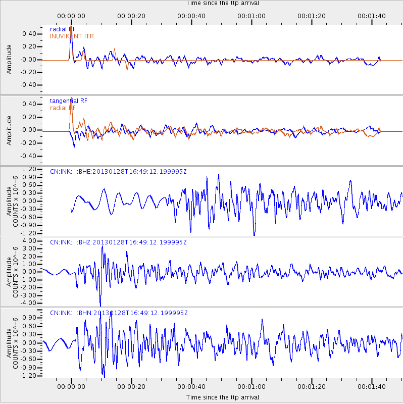
INK INUVIK, NT - Earthquake Result Viewer
*The percent match for this event was below the threshold and hence no stack was calculated.
| Earthquake location: |
Lake Issyk-Kul Region |
| Earthquake latitude/longitude: |
42.6/79.7 |
| Earthquake time(UTC): |
2013/01/28 (028) 16:38:53 GMT |
| Earthquake Depth: |
15 km |
| Earthquake Magnitude: |
6.1 MB, 6.2 MS, 6.1 MW, 6.1 MW |
| Earthquake Catalog/Contributor: |
WHDF/NEIC |
|
| Network: |
CN Canadian National Seismograph Network |
| Station: |
INK INUVIK, NT |
| Lat/Lon: |
68.31 N/133.53 W |
| Elevation: |
44 m |
|
| Distance: |
66.6 deg |
| Az: |
12.824 deg |
| Baz: |
333.848 deg |
| Ray Param: |
$rayparam |
*The percent match for this event was below the threshold and hence was not used in the summary stack. |
|
| Radial Match: |
79.30806 % |
| Radial Bump: |
400 |
| Transverse Match: |
61.463745 % |
| Transverse Bump: |
400 |
| SOD ConfigId: |
494114 |
| Insert Time: |
2013-04-24 03:53:19.245 +0000 |
| GWidth: |
2.5 |
| Max Bumps: |
400 |
| Tol: |
0.001 |
|
Signal To Noise
| Channel | StoN | STA | LTA |
| CN:INK: :BHZ:20130128T16:49:12.199995Z | 3.6453052 | 7.2402975E-7 | 1.9861979E-7 |
| CN:INK: :BHN:20130128T16:49:12.199995Z | 3.3722792 | 4.3996604E-7 | 1.3046548E-7 |
| CN:INK: :BHE:20130128T16:49:12.199995Z | 1.0183656 | 2.3022963E-7 | 2.2607757E-7 |
| Arrivals |
| Ps | |
| PpPs | |
| PsPs/PpSs | |


