You are here: Home > Network List > TA - USArray Transportable Network (new EarthScope stations) Stations List
> Station F37A Hinrichs Farm, Grantsburg, WI, USA > Earthquake Result Viewer
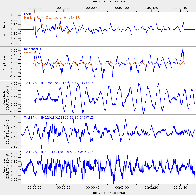
F37A Hinrichs Farm, Grantsburg, WI, USA - Earthquake Result Viewer
*The percent match for this event was below the threshold and hence no stack was calculated.
| Earthquake location: |
Lake Issyk-Kul Region |
| Earthquake latitude/longitude: |
42.6/79.7 |
| Earthquake time(UTC): |
2013/01/28 (028) 16:38:53 GMT |
| Earthquake Depth: |
15 km |
| Earthquake Magnitude: |
6.1 MB, 6.2 MS, 6.1 MW, 6.1 MW |
| Earthquake Catalog/Contributor: |
WHDF/NEIC |
|
| Network: |
TA USArray Transportable Network (new EarthScope stations) |
| Station: |
F37A Hinrichs Farm, Grantsburg, WI, USA |
| Lat/Lon: |
45.72 N/92.63 W |
| Elevation: |
296 m |
|
| Distance: |
91.8 deg |
| Az: |
354.636 deg |
| Baz: |
5.655 deg |
| Ray Param: |
$rayparam |
*The percent match for this event was below the threshold and hence was not used in the summary stack. |
|
| Radial Match: |
55.499004 % |
| Radial Bump: |
400 |
| Transverse Match: |
62.446552 % |
| Transverse Bump: |
400 |
| SOD ConfigId: |
494114 |
| Insert Time: |
2013-04-24 03:57:50.417 +0000 |
| GWidth: |
2.5 |
| Max Bumps: |
400 |
| Tol: |
0.001 |
|
Signal To Noise
| Channel | StoN | STA | LTA |
| TA:F37A: :BHZ:20130128T16:51:29.049971Z | 1.1554378 | 6.182482E-7 | 5.35077E-7 |
| TA:F37A: :BHN:20130128T16:51:29.049971Z | 1.1805844 | 3.607699E-7 | 3.0558587E-7 |
| TA:F37A: :BHE:20130128T16:51:29.049971Z | 1.7441876 | 2.8609022E-6 | 1.6402491E-6 |
| Arrivals |
| Ps | |
| PpPs | |
| PsPs/PpSs | |


