You are here: Home > Network List > TA - USArray Transportable Network (new EarthScope stations) Stations List
> Station W47A Westpoint, TN, USA > Earthquake Result Viewer
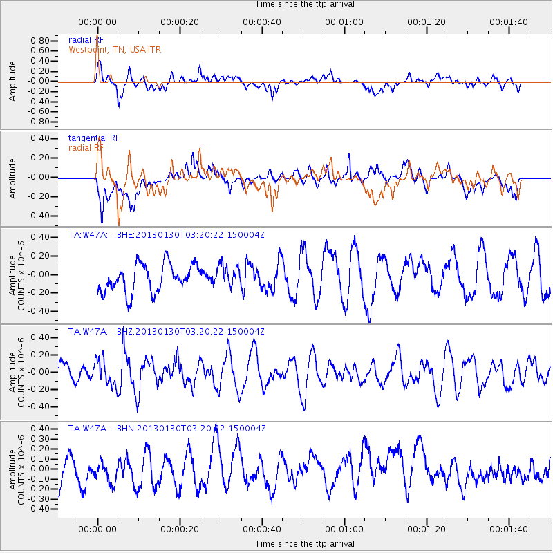
W47A Westpoint, TN, USA - Earthquake Result Viewer
*The percent match for this event was below the threshold and hence no stack was calculated.
| Earthquake location: |
Off Coast Of Oregon |
| Earthquake latitude/longitude: |
43.6/-127.6 |
| Earthquake time(UTC): |
2013/01/30 (030) 03:14:28 GMT |
| Earthquake Depth: |
10 km |
| Earthquake Magnitude: |
5.6 MB, 5.4 MW, 5.4 MW |
| Earthquake Catalog/Contributor: |
WHDF/NEIC |
|
| Network: |
TA USArray Transportable Network (new EarthScope stations) |
| Station: |
W47A Westpoint, TN, USA |
| Lat/Lon: |
35.25 N/87.59 W |
| Elevation: |
293 m |
|
| Distance: |
31.8 deg |
| Az: |
91.505 deg |
| Baz: |
297.53 deg |
| Ray Param: |
$rayparam |
*The percent match for this event was below the threshold and hence was not used in the summary stack. |
|
| Radial Match: |
47.513313 % |
| Radial Bump: |
400 |
| Transverse Match: |
46.73287 % |
| Transverse Bump: |
400 |
| SOD ConfigId: |
494114 |
| Insert Time: |
2013-04-27 03:29:19.648 +0000 |
| GWidth: |
2.5 |
| Max Bumps: |
400 |
| Tol: |
0.001 |
|
Signal To Noise
| Channel | StoN | STA | LTA |
| TA:W47A: :BHZ:20130130T03:20:22.150004Z | 0.8781603 | 1.4776039E-7 | 1.682613E-7 |
| TA:W47A: :BHN:20130130T03:20:22.150004Z | 0.6701147 | 1.656769E-7 | 2.472366E-7 |
| TA:W47A: :BHE:20130130T03:20:22.150004Z | 0.76429874 | 1.1464655E-7 | 1.5000228E-7 |
| Arrivals |
| Ps | |
| PpPs | |
| PsPs/PpSs | |


