You are here: Home > Network List > TA - USArray Transportable Network (new EarthScope stations) Stations List
> Station M47A Cromwell, IN, USA > Earthquake Result Viewer
M47A Cromwell, IN, USA - Earthquake Result Viewer
*The percent match for this event was below the threshold and hence no stack was calculated.
| Earthquake location: |
Off Coast Of Oregon |
| Earthquake latitude/longitude: |
43.6/-127.6 |
| Earthquake time(UTC): |
2013/01/30 (030) 03:14:28 GMT |
| Earthquake Depth: |
10 km |
| Earthquake Magnitude: |
5.6 MB, 5.4 MW, 5.4 MW |
| Earthquake Catalog/Contributor: |
WHDF/NEIC |
|
| Network: |
TA USArray Transportable Network (new EarthScope stations) |
| Station: |
M47A Cromwell, IN, USA |
| Lat/Lon: |
41.36 N/85.62 W |
| Elevation: |
283 m |
|
| Distance: |
30.8 deg |
| Az: |
79.515 deg |
| Baz: |
288.494 deg |
| Ray Param: |
$rayparam |
*The percent match for this event was below the threshold and hence was not used in the summary stack. |
|
| Radial Match: |
38.5149 % |
| Radial Bump: |
400 |
| Transverse Match: |
53.342358 % |
| Transverse Bump: |
400 |
| SOD ConfigId: |
494114 |
| Insert Time: |
2013-04-27 03:30:55.428 +0000 |
| GWidth: |
2.5 |
| Max Bumps: |
400 |
| Tol: |
0.001 |
|
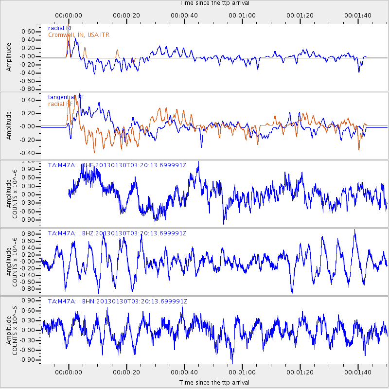
Signal To Noise
| Channel | StoN | STA | LTA |
| TA:M47A: :BHZ:20130130T03:20:13.699991Z | 2.54466 | 3.8642685E-7 | 1.5185795E-7 |
| TA:M47A: :BHN:20130130T03:20:13.699991Z | 0.985445 | 3.167425E-7 | 3.2142077E-7 |
| TA:M47A: :BHE:20130130T03:20:13.699991Z | 2.134541 | 8.369102E-7 | 3.920797E-7 |
| Arrivals |
| Ps | |
| PpPs | |
| PsPs/PpSs | |


