You are here: Home > Network List > TA - USArray Transportable Network (new EarthScope stations) Stations List
> Station K48A Perry, MI, USA > Earthquake Result Viewer
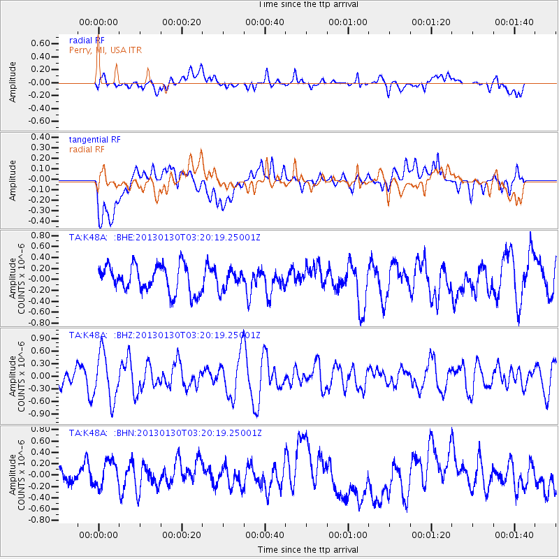
K48A Perry, MI, USA - Earthquake Result Viewer
*The percent match for this event was below the threshold and hence no stack was calculated.
| Earthquake location: |
Off Coast Of Oregon |
| Earthquake latitude/longitude: |
43.6/-127.6 |
| Earthquake time(UTC): |
2013/01/30 (030) 03:14:28 GMT |
| Earthquake Depth: |
10 km |
| Earthquake Magnitude: |
5.6 MB, 5.4 MW, 5.4 MW |
| Earthquake Catalog/Contributor: |
WHDF/NEIC |
|
| Network: |
TA USArray Transportable Network (new EarthScope stations) |
| Station: |
K48A Perry, MI, USA |
| Lat/Lon: |
42.80 N/84.12 W |
| Elevation: |
273 m |
|
| Distance: |
31.4 deg |
| Az: |
76.201 deg |
| Baz: |
286.66 deg |
| Ray Param: |
$rayparam |
*The percent match for this event was below the threshold and hence was not used in the summary stack. |
|
| Radial Match: |
51.387432 % |
| Radial Bump: |
400 |
| Transverse Match: |
50.669262 % |
| Transverse Bump: |
400 |
| SOD ConfigId: |
494114 |
| Insert Time: |
2013-04-27 03:31:01.396 +0000 |
| GWidth: |
2.5 |
| Max Bumps: |
400 |
| Tol: |
0.001 |
|
Signal To Noise
| Channel | StoN | STA | LTA |
| TA:K48A: :BHZ:20130130T03:20:19.25001Z | 2.7915652 | 5.6973556E-7 | 2.0409179E-7 |
| TA:K48A: :BHN:20130130T03:20:19.25001Z | 1.0832001 | 2.785062E-7 | 2.5711427E-7 |
| TA:K48A: :BHE:20130130T03:20:19.25001Z | 0.70078444 | 1.7366932E-7 | 2.478213E-7 |
| Arrivals |
| Ps | |
| PpPs | |
| PsPs/PpSs | |


