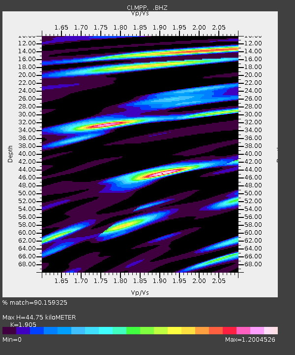
MPP McPhearson Peak - Earthquake Result Viewer
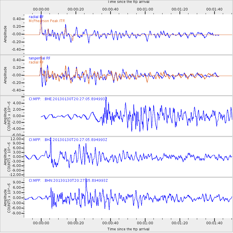
Earthquake location: Central Chile
Earthquake latitude/longitude: -28.1/-70.7
Earthquake time(UTC): 2013/01/30 (030) 20:15:43 GMT
Earthquake Depth: 45 km
Earthquake Magnitude: 6.5 MB, 6.5 MS, 6.8 MW, 6.8 MW
Earthquake Catalog/Contributor: WHDF/NEIC
Network: CI Caltech Regional Seismic Network
Station: MPP McPhearson Peak
Lat/Lon: 34.89 N/119.81 W
Elevation: 1739 m
Distance: 78.0 deg
Az: 320.516 deg
Baz: 136.892 deg
Ray Param: 0.049873967
Estimated Moho Depth: 44.75 km
Estimated Crust Vp/Vs: 1.90
Assumed Crust Vp: 6.1 km/s
Estimated Crust Vs: 3.202 km/s
Estimated Crust Poisson's Ratio: 0.31
Radial Match: 90.159325 %
Radial Bump: 400
Transverse Match: 83.468475 %
Transverse Bump: 400
SOD ConfigId: 494114
Insert Time: 2013-04-27 03:38:53.522 +0000
GWidth: 2.5
Max Bumps: 400
Tol: 0.001

Signal To Noise

ChannelStoNSTALTA
CI:MPP: :BHZ:20130130T20:27:05.894993Z2.97917081.7388212E-65.836594E-7
CI:MPP: :BHN:20130130T20:27:05.894993Z1.60495516.523348E-74.0645048E-7
CI:MPP: :BHE:20130130T20:27:05.894993Z2.90665171.0748022E-63.6977326E-7
Arrivals
Ps6.8 SECOND
PpPs21 SECOND
PsPs/PpSs28 SECOND