You are here: Home > Network List > TA - USArray Transportable Network (new EarthScope stations) Stations List
> Station H17A Grant Village (NPS), Yellowstone Nt. Park, WY, USA > Earthquake Result Viewer
H17A Grant Village (NPS), Yellowstone Nt. Park, WY, USA - Earthquake Result Viewer
| Earthquake location: |
Central Chile |
| Earthquake latitude/longitude: |
-28.1/-70.7 |
| Earthquake time(UTC): |
2013/01/30 (030) 20:15:43 GMT |
| Earthquake Depth: |
45 km |
| Earthquake Magnitude: |
6.5 MB, 6.5 MS, 6.8 MW, 6.8 MW |
| Earthquake Catalog/Contributor: |
WHDF/NEIC |
|
| Network: |
TA USArray Transportable Network (new EarthScope stations) |
| Station: |
H17A Grant Village (NPS), Yellowstone Nt. Park, WY, USA |
| Lat/Lon: |
44.40 N/110.58 W |
| Elevation: |
2400 m |
|
| Distance: |
80.8 deg |
| Az: |
332.225 deg |
| Baz: |
144.949 deg |
| Ray Param: |
0.047926895 |
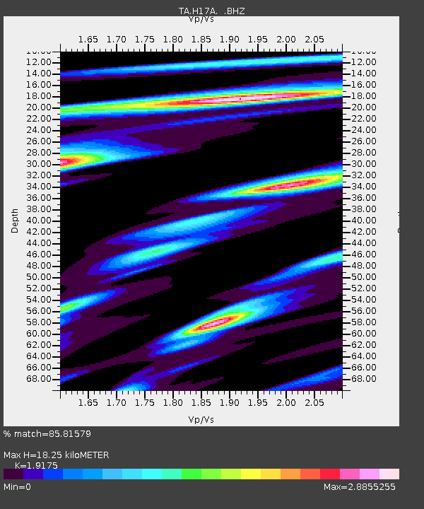
| Estimated Moho Depth: |
18.25 km |
| Estimated Crust Vp/Vs: |
1.92 |
| Assumed Crust Vp: |
6.35 km/s |
| Estimated Crust Vs: |
3.312 km/s |
| Estimated Crust Poisson's Ratio: |
0.31 |
|
| Radial Match: |
85.81579 % |
| Radial Bump: |
400 |
| Transverse Match: |
87.813896 % |
| Transverse Bump: |
400 |
| SOD ConfigId: |
494114 |
| Insert Time: |
2013-04-27 03:49:30.463 +0000 |
| GWidth: |
2.5 |
| Max Bumps: |
400 |
| Tol: |
0.001 |
|

Signal To Noise
| Channel | StoN | STA | LTA |
| TA:H17A: :BHZ:20130130T20:27:21.399998Z | 20.67352 | 2.0837308E-6 | 1.0079227E-7 |
| TA:H17A: :BHN:20130130T20:27:21.399998Z | 5.3815866 | 8.043435E-7 | 1.4946214E-7 |
| TA:H17A: :BHE:20130130T20:27:21.399998Z | 5.1801767 | 6.509935E-7 | 1.2567014E-7 |
| Arrivals |
| Ps | 2.7 SECOND |
| PpPs | 8.2 SECOND |
| PsPs/PpSs | 11 SECOND |


