You are here: Home > Network List > IU - Global Seismograph Network (GSN - IRIS/USGS) Stations List
> Station FURI Mt. Furi, Ethiopia > Earthquake Result Viewer
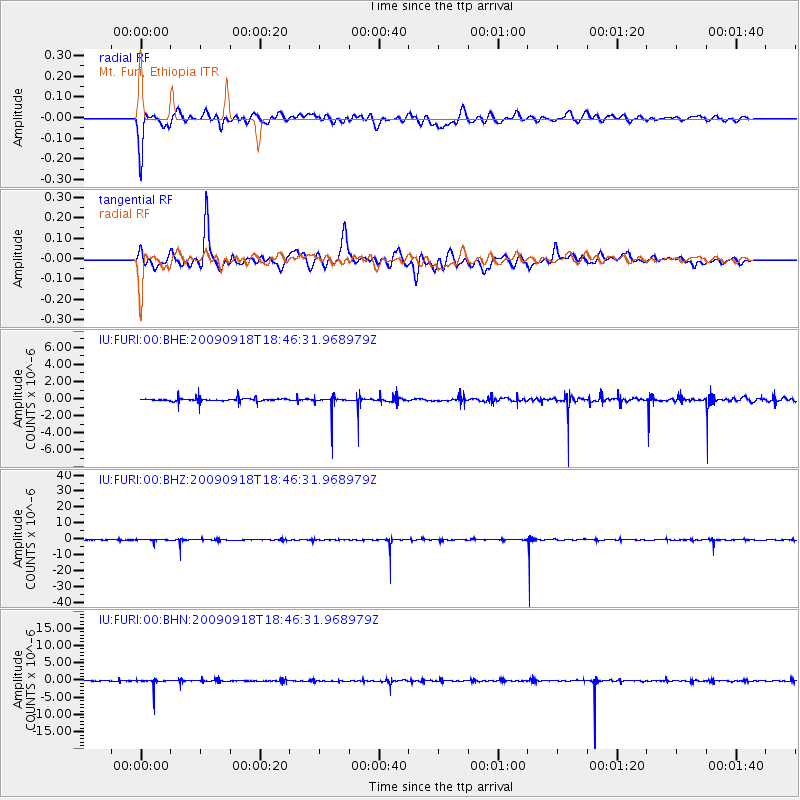
FURI Mt. Furi, Ethiopia - Earthquake Result Viewer
*The percent match for this event was below the threshold and hence no stack was calculated.
| Earthquake location: |
Halmahera, Indonesia |
| Earthquake latitude/longitude: |
1.8/127.2 |
| Earthquake time(UTC): |
2009/09/18 (261) 18:34:22 GMT |
| Earthquake Depth: |
93 km |
| Earthquake Magnitude: |
5.7 MB, 5.8 MW, 5.8 MW |
| Earthquake Catalog/Contributor: |
WHDF/NEIC |
|
| Network: |
IU Global Seismograph Network (GSN - IRIS/USGS) |
| Station: |
FURI Mt. Furi, Ethiopia |
| Lat/Lon: |
8.90 N/38.68 E |
| Elevation: |
2570 m |
|
| Distance: |
88.3 deg |
| Az: |
278.791 deg |
| Baz: |
88.506 deg |
| Ray Param: |
$rayparam |
*The percent match for this event was below the threshold and hence was not used in the summary stack. |
|
| Radial Match: |
57.704933 % |
| Radial Bump: |
400 |
| Transverse Match: |
63.10411 % |
| Transverse Bump: |
400 |
| SOD ConfigId: |
1 |
| Insert Time: |
2010-02-19 00:15:09.467 +0000 |
| GWidth: |
2.5 |
| Max Bumps: |
400 |
| Tol: |
0.001 |
|
Signal To Noise
| Channel | StoN | STA | LTA |
| IU:FURI:00:BHZ:20090918T18:46:31.968979Z | 3.1266658 | 6.91236E-7 | 2.2107766E-7 |
| IU:FURI:00:BHN:20090918T18:46:31.968979Z | 6.498174 | 1.1875986E-6 | 1.8275881E-7 |
| IU:FURI:00:BHE:20090918T18:46:31.968979Z | 3.9280608 | 8.4664003E-7 | 2.1553639E-7 |
| Arrivals |
| Ps | |
| PpPs | |
| PsPs/PpSs | |


