You are here: Home > Network List > TA - USArray Transportable Network (new EarthScope stations) Stations List
> Station O56A Blue Knob State Park, Imler, PA, USA > Earthquake Result Viewer
O56A Blue Knob State Park, Imler, PA, USA - Earthquake Result Viewer
| Earthquake location: |
Central Chile |
| Earthquake latitude/longitude: |
-28.1/-70.7 |
| Earthquake time(UTC): |
2013/01/30 (030) 20:15:43 GMT |
| Earthquake Depth: |
45 km |
| Earthquake Magnitude: |
6.5 MB, 6.5 MS, 6.8 MW, 6.8 MW |
| Earthquake Catalog/Contributor: |
WHDF/NEIC |
|
| Network: |
TA USArray Transportable Network (new EarthScope stations) |
| Station: |
O56A Blue Knob State Park, Imler, PA, USA |
| Lat/Lon: |
40.27 N/78.57 W |
| Elevation: |
684 m |
|
| Distance: |
68.4 deg |
| Az: |
353.495 deg |
| Baz: |
172.484 deg |
| Ray Param: |
0.056236364 |
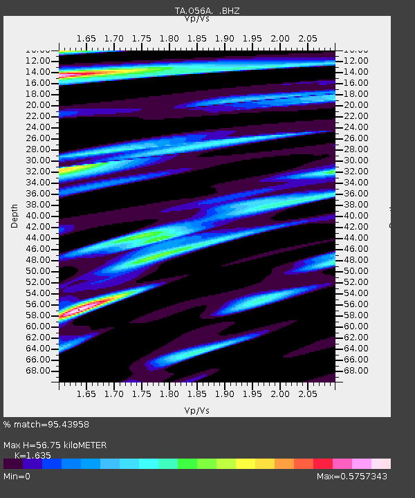
| Estimated Moho Depth: |
56.75 km |
| Estimated Crust Vp/Vs: |
1.63 |
| Assumed Crust Vp: |
6.121 km/s |
| Estimated Crust Vs: |
3.743 km/s |
| Estimated Crust Poisson's Ratio: |
0.20 |
|
| Radial Match: |
95.43958 % |
| Radial Bump: |
362 |
| Transverse Match: |
87.45834 % |
| Transverse Bump: |
400 |
| SOD ConfigId: |
494114 |
| Insert Time: |
2013-04-27 03:53:12.202 +0000 |
| GWidth: |
2.5 |
| Max Bumps: |
400 |
| Tol: |
0.001 |
|
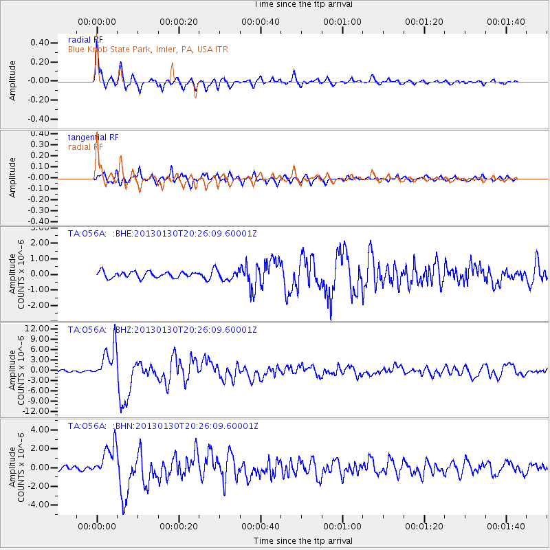
Signal To Noise
| Channel | StoN | STA | LTA |
| TA:O56A: :BHZ:20130130T20:26:09.60001Z | 25.098606 | 5.1541556E-6 | 2.0535626E-7 |
| TA:O56A: :BHN:20130130T20:26:09.60001Z | 8.460032 | 1.7599214E-6 | 2.0802774E-7 |
| TA:O56A: :BHE:20130130T20:26:09.60001Z | 1.618602 | 3.062108E-7 | 1.8918227E-7 |
| Arrivals |
| Ps | 6.1 SECOND |
| PpPs | 24 SECOND |
| PsPs/PpSs | 30 SECOND |


