You are here: Home > Network List > TA - USArray Transportable Network (new EarthScope stations) Stations List
> Station W41B Gary Mavity, Velonia, AR, USA > Earthquake Result Viewer
W41B Gary Mavity, Velonia, AR, USA - Earthquake Result Viewer
| Earthquake location: |
Central Chile |
| Earthquake latitude/longitude: |
-28.1/-70.7 |
| Earthquake time(UTC): |
2013/01/30 (030) 20:15:43 GMT |
| Earthquake Depth: |
45 km |
| Earthquake Magnitude: |
6.5 MB, 6.5 MS, 6.8 MW, 6.8 MW |
| Earthquake Catalog/Contributor: |
WHDF/NEIC |
|
| Network: |
TA USArray Transportable Network (new EarthScope stations) |
| Station: |
W41B Gary Mavity, Velonia, AR, USA |
| Lat/Lon: |
35.17 N/92.25 W |
| Elevation: |
95 m |
|
| Distance: |
66.2 deg |
| Az: |
340.752 deg |
| Baz: |
159.175 deg |
| Ray Param: |
0.05771563 |
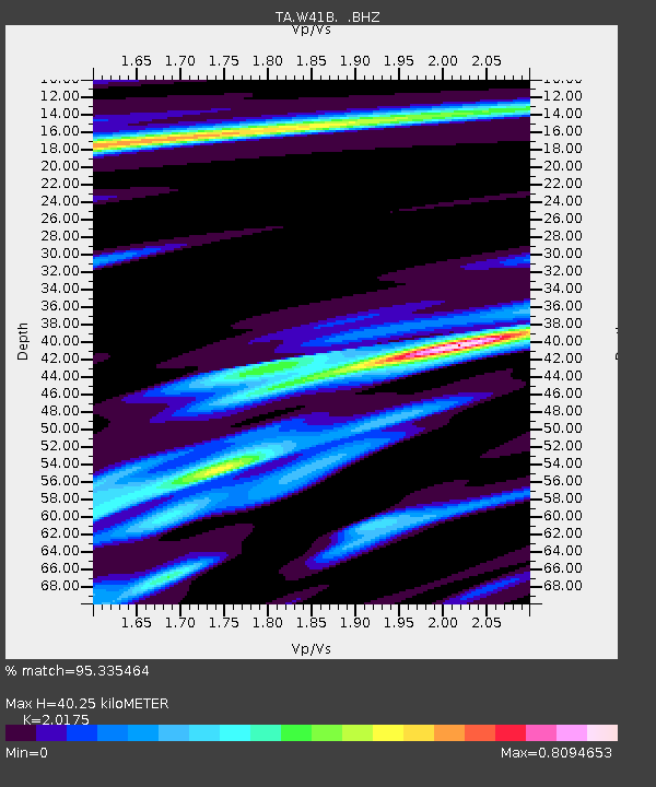
| Estimated Moho Depth: |
40.25 km |
| Estimated Crust Vp/Vs: |
2.02 |
| Assumed Crust Vp: |
6.498 km/s |
| Estimated Crust Vs: |
3.221 km/s |
| Estimated Crust Poisson's Ratio: |
0.34 |
|
| Radial Match: |
95.335464 % |
| Radial Bump: |
400 |
| Transverse Match: |
85.71489 % |
| Transverse Bump: |
400 |
| SOD ConfigId: |
494114 |
| Insert Time: |
2013-04-27 03:54:09.202 +0000 |
| GWidth: |
2.5 |
| Max Bumps: |
400 |
| Tol: |
0.001 |
|
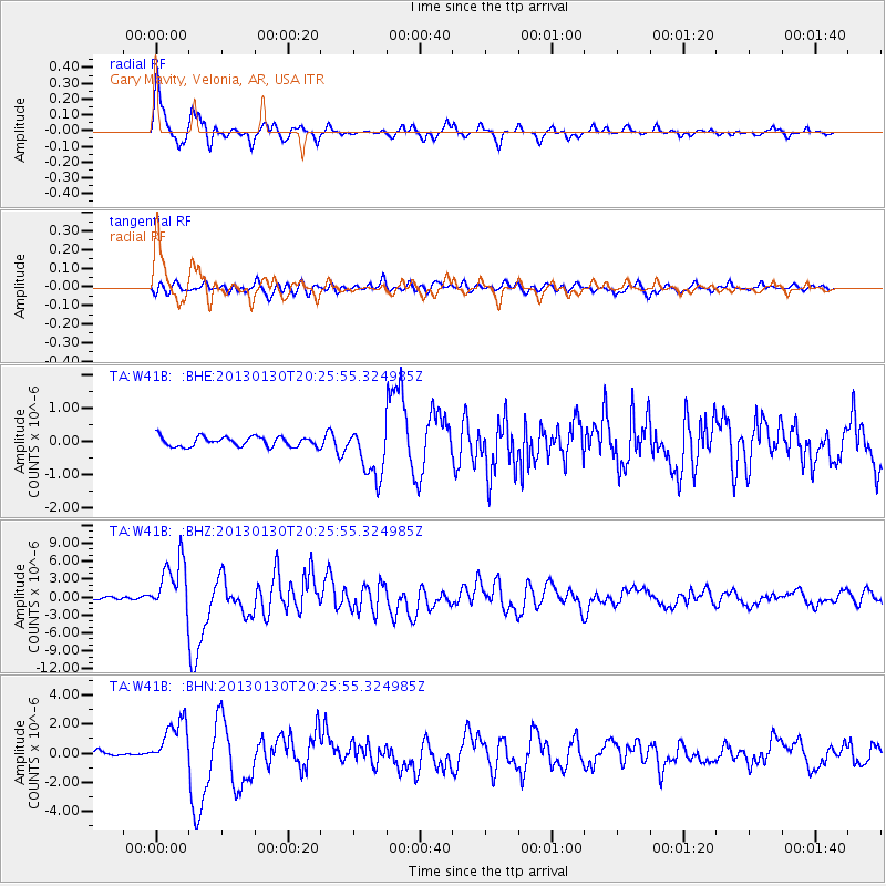
Signal To Noise
| Channel | StoN | STA | LTA |
| TA:W41B: :BHZ:20130130T20:25:55.324985Z | 14.086649 | 4.5216243E-6 | 3.2098652E-7 |
| TA:W41B: :BHN:20130130T20:25:55.324985Z | 6.105591 | 1.6471148E-6 | 2.6977156E-7 |
| TA:W41B: :BHE:20130130T20:25:55.324985Z | 5.40206 | 7.8261843E-7 | 1.4487406E-7 |
| Arrivals |
| Ps | 6.5 SECOND |
| PpPs | 18 SECOND |
| PsPs/PpSs | 25 SECOND |


