You are here: Home > Network List > TA - USArray Transportable Network (new EarthScope stations) Stations List
> Station X45A UM Field Station, Abbeville, MS, USA > Earthquake Result Viewer
X45A UM Field Station, Abbeville, MS, USA - Earthquake Result Viewer
| Earthquake location: |
Central Chile |
| Earthquake latitude/longitude: |
-28.1/-70.7 |
| Earthquake time(UTC): |
2013/01/30 (030) 20:15:43 GMT |
| Earthquake Depth: |
45 km |
| Earthquake Magnitude: |
6.5 MB, 6.5 MS, 6.8 MW, 6.8 MW |
| Earthquake Catalog/Contributor: |
WHDF/NEIC |
|
| Network: |
TA USArray Transportable Network (new EarthScope stations) |
| Station: |
X45A UM Field Station, Abbeville, MS, USA |
| Lat/Lon: |
34.42 N/89.39 W |
| Elevation: |
142 m |
|
| Distance: |
64.7 deg |
| Az: |
342.911 deg |
| Baz: |
161.696 deg |
| Ray Param: |
0.05869166 |
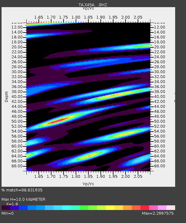
| Estimated Moho Depth: |
10.0 km |
| Estimated Crust Vp/Vs: |
1.60 |
| Assumed Crust Vp: |
6.38 km/s |
| Estimated Crust Vs: |
3.988 km/s |
| Estimated Crust Poisson's Ratio: |
0.18 |
|
| Radial Match: |
86.631935 % |
| Radial Bump: |
400 |
| Transverse Match: |
75.21181 % |
| Transverse Bump: |
400 |
| SOD ConfigId: |
494114 |
| Insert Time: |
2013-04-27 03:55:53.932 +0000 |
| GWidth: |
2.5 |
| Max Bumps: |
400 |
| Tol: |
0.001 |
|

Signal To Noise
| Channel | StoN | STA | LTA |
| TA:X45A: :BHZ:20130130T20:25:45.72501Z | 23.58879 | 5.120988E-6 | 2.1709413E-7 |
| TA:X45A: :BHN:20130130T20:25:45.72501Z | 5.38965 | 2.774666E-6 | 5.148138E-7 |
| TA:X45A: :BHE:20130130T20:25:45.72501Z | 1.5974655 | 9.804626E-7 | 6.137613E-7 |
| Arrivals |
| Ps | 1.0 SECOND |
| PpPs | 3.9 SECOND |
| PsPs/PpSs | 4.9 SECOND |


