You are here: Home > Network List > TA - USArray Transportable Network (new EarthScope stations) Stations List
> Station H38A Maiden Rock, WI, USA > Earthquake Result Viewer
H38A Maiden Rock, WI, USA - Earthquake Result Viewer
| Earthquake location: |
Central Chile |
| Earthquake latitude/longitude: |
-28.1/-70.7 |
| Earthquake time(UTC): |
2013/01/30 (030) 20:15:43 GMT |
| Earthquake Depth: |
45 km |
| Earthquake Magnitude: |
6.5 MB, 6.5 MS, 6.8 MW, 6.8 MW |
| Earthquake Catalog/Contributor: |
WHDF/NEIC |
|
| Network: |
TA USArray Transportable Network (new EarthScope stations) |
| Station: |
H38A Maiden Rock, WI, USA |
| Lat/Lon: |
44.68 N/92.28 W |
| Elevation: |
333 m |
|
| Distance: |
75.1 deg |
| Az: |
344.207 deg |
| Baz: |
160.304 deg |
| Ray Param: |
0.051837076 |
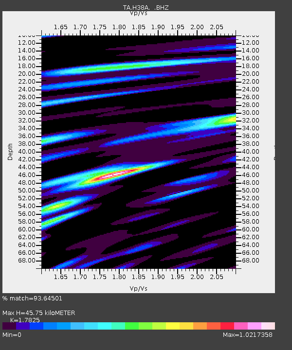
| Estimated Moho Depth: |
45.75 km |
| Estimated Crust Vp/Vs: |
1.78 |
| Assumed Crust Vp: |
6.571 km/s |
| Estimated Crust Vs: |
3.686 km/s |
| Estimated Crust Poisson's Ratio: |
0.27 |
|
| Radial Match: |
93.64501 % |
| Radial Bump: |
400 |
| Transverse Match: |
83.36514 % |
| Transverse Bump: |
400 |
| SOD ConfigId: |
494114 |
| Insert Time: |
2013-04-27 04:00:01.050 +0000 |
| GWidth: |
2.5 |
| Max Bumps: |
400 |
| Tol: |
0.001 |
|
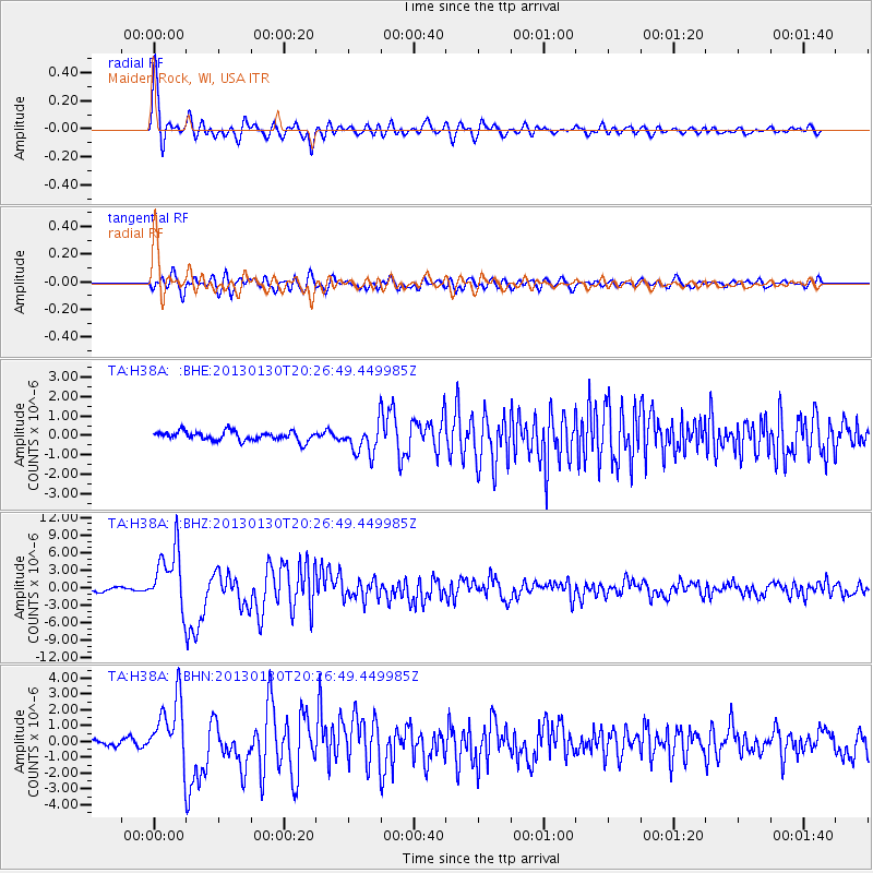
Signal To Noise
| Channel | StoN | STA | LTA |
| TA:H38A: :BHZ:20130130T20:26:49.449985Z | 17.068373 | 5.1332963E-6 | 3.00749E-7 |
| TA:H38A: :BHN:20130130T20:26:49.449985Z | 8.182773 | 2.049091E-6 | 2.5041527E-7 |
| TA:H38A: :BHE:20130130T20:26:49.449985Z | 3.2055628 | 7.7127817E-7 | 2.4060617E-7 |
| Arrivals |
| Ps | 5.6 SECOND |
| PpPs | 19 SECOND |
| PsPs/PpSs | 24 SECOND |


