You are here: Home > Network List > TA - USArray Transportable Network (new EarthScope stations) Stations List
> Station N42A Yates City, IL, USA > Earthquake Result Viewer
N42A Yates City, IL, USA - Earthquake Result Viewer
| Earthquake location: |
Central Chile |
| Earthquake latitude/longitude: |
-28.1/-70.7 |
| Earthquake time(UTC): |
2013/01/30 (030) 20:15:43 GMT |
| Earthquake Depth: |
45 km |
| Earthquake Magnitude: |
6.5 MB, 6.5 MS, 6.8 MW, 6.8 MW |
| Earthquake Catalog/Contributor: |
WHDF/NEIC |
|
| Network: |
TA USArray Transportable Network (new EarthScope stations) |
| Station: |
N42A Yates City, IL, USA |
| Lat/Lon: |
40.83 N/90.03 W |
| Elevation: |
205 m |
|
| Distance: |
70.9 deg |
| Az: |
344.544 deg |
| Baz: |
161.924 deg |
| Ray Param: |
0.05459696 |
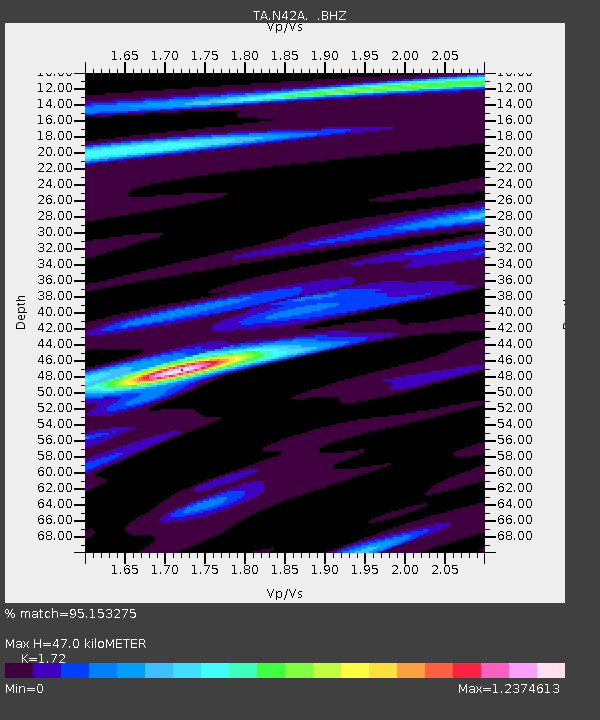
| Estimated Moho Depth: |
47.0 km |
| Estimated Crust Vp/Vs: |
1.72 |
| Assumed Crust Vp: |
6.498 km/s |
| Estimated Crust Vs: |
3.778 km/s |
| Estimated Crust Poisson's Ratio: |
0.24 |
|
| Radial Match: |
95.153275 % |
| Radial Bump: |
400 |
| Transverse Match: |
76.12982 % |
| Transverse Bump: |
400 |
| SOD ConfigId: |
494114 |
| Insert Time: |
2013-04-27 04:00:36.461 +0000 |
| GWidth: |
2.5 |
| Max Bumps: |
400 |
| Tol: |
0.001 |
|
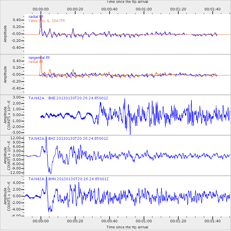
Signal To Noise
| Channel | StoN | STA | LTA |
| TA:N42A: :BHZ:20130130T20:26:24.85001Z | 31.63384 | 6.0337056E-6 | 1.9073579E-7 |
| TA:N42A: :BHN:20130130T20:26:24.85001Z | 7.1023655 | 2.3406035E-6 | 3.2955268E-7 |
| TA:N42A: :BHE:20130130T20:26:24.85001Z | 3.3201873 | 9.3905993E-7 | 2.8283344E-7 |
| Arrivals |
| Ps | 5.4 SECOND |
| PpPs | 19 SECOND |
| PsPs/PpSs | 24 SECOND |


