You are here: Home > Network List > TA - USArray Transportable Network (new EarthScope stations) Stations List
> Station E45A Wooded Hills, Hulbert, MI, USA > Earthquake Result Viewer
E45A Wooded Hills, Hulbert, MI, USA - Earthquake Result Viewer
| Earthquake location: |
Central Chile |
| Earthquake latitude/longitude: |
-28.1/-70.7 |
| Earthquake time(UTC): |
2013/01/30 (030) 20:15:43 GMT |
| Earthquake Depth: |
45 km |
| Earthquake Magnitude: |
6.5 MB, 6.5 MS, 6.8 MW, 6.8 MW |
| Earthquake Catalog/Contributor: |
WHDF/NEIC |
|
| Network: |
TA USArray Transportable Network (new EarthScope stations) |
| Station: |
E45A Wooded Hills, Hulbert, MI, USA |
| Lat/Lon: |
46.36 N/85.18 W |
| Elevation: |
251 m |
|
| Distance: |
75.3 deg |
| Az: |
349.653 deg |
| Baz: |
166.755 deg |
| Ray Param: |
0.05170909 |
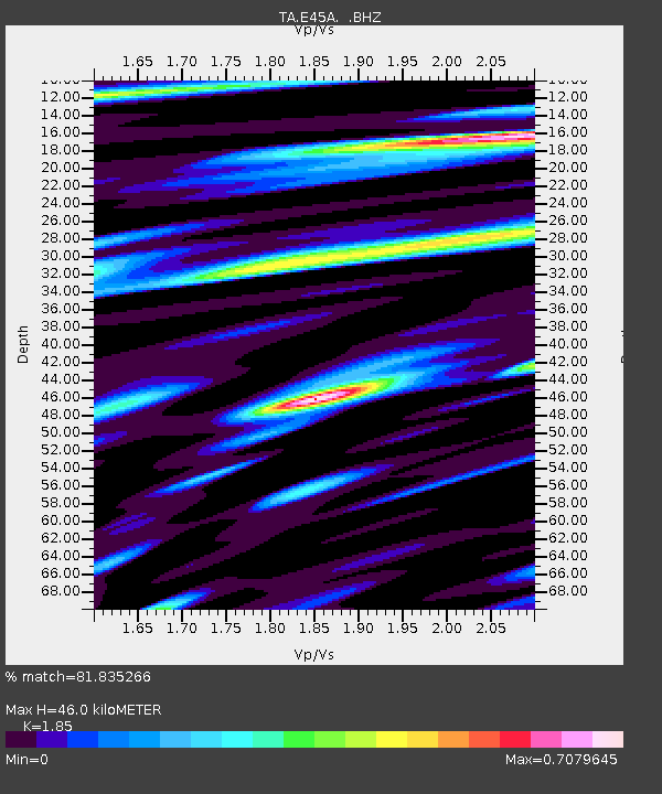
| Estimated Moho Depth: |
46.0 km |
| Estimated Crust Vp/Vs: |
1.85 |
| Assumed Crust Vp: |
6.467 km/s |
| Estimated Crust Vs: |
3.495 km/s |
| Estimated Crust Poisson's Ratio: |
0.29 |
|
| Radial Match: |
81.835266 % |
| Radial Bump: |
400 |
| Transverse Match: |
67.67791 % |
| Transverse Bump: |
400 |
| SOD ConfigId: |
494114 |
| Insert Time: |
2013-04-27 04:02:20.126 +0000 |
| GWidth: |
2.5 |
| Max Bumps: |
400 |
| Tol: |
0.001 |
|
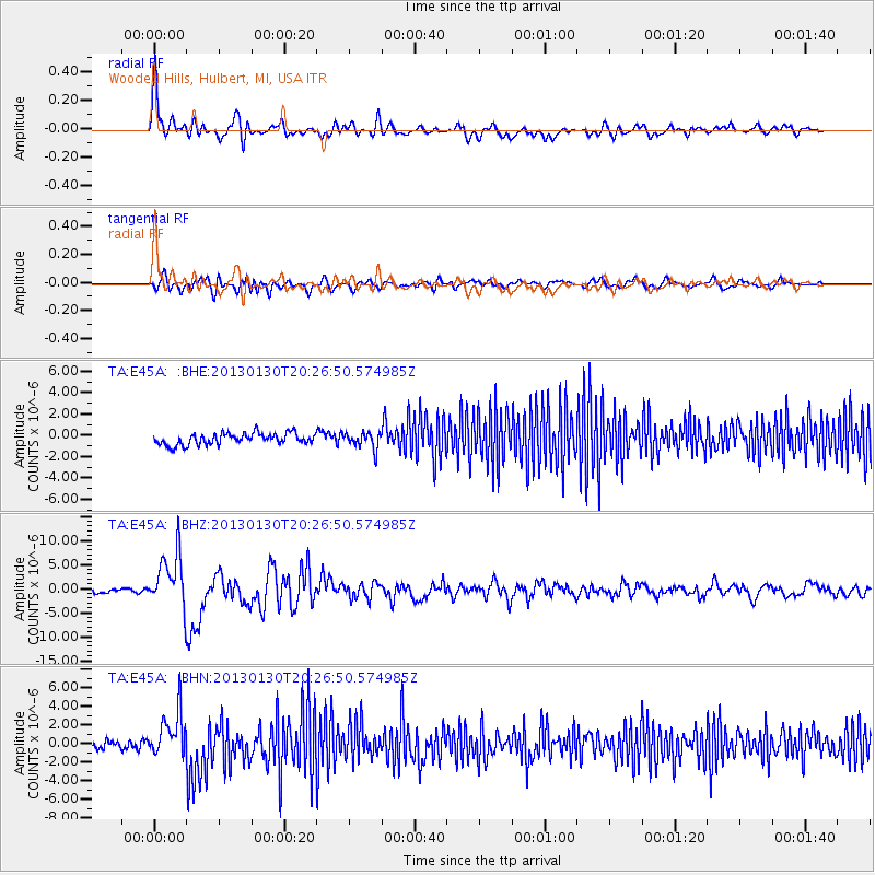
Signal To Noise
| Channel | StoN | STA | LTA |
| TA:E45A: :BHZ:20130130T20:26:50.574985Z | 13.574014 | 5.6925737E-6 | 4.1937292E-7 |
| TA:E45A: :BHN:20130130T20:26:50.574985Z | 3.9871569 | 2.2962993E-6 | 5.75924E-7 |
| TA:E45A: :BHE:20130130T20:26:50.574985Z | 1.4355688 | 7.5796953E-7 | 5.279925E-7 |
| Arrivals |
| Ps | 6.2 SECOND |
| PpPs | 20 SECOND |
| PsPs/PpSs | 26 SECOND |


