You are here: Home > Network List > TA - USArray Transportable Network (new EarthScope stations) Stations List
> Station M46A Old House Field, Plymouth, IN, USA > Earthquake Result Viewer
M46A Old House Field, Plymouth, IN, USA - Earthquake Result Viewer
| Earthquake location: |
Central Chile |
| Earthquake latitude/longitude: |
-28.1/-70.7 |
| Earthquake time(UTC): |
2013/01/30 (030) 20:15:43 GMT |
| Earthquake Depth: |
45 km |
| Earthquake Magnitude: |
6.5 MB, 6.5 MS, 6.8 MW, 6.8 MW |
| Earthquake Catalog/Contributor: |
WHDF/NEIC |
|
| Network: |
TA USArray Transportable Network (new EarthScope stations) |
| Station: |
M46A Old House Field, Plymouth, IN, USA |
| Lat/Lon: |
41.41 N/86.35 W |
| Elevation: |
242 m |
|
| Distance: |
70.7 deg |
| Az: |
347.543 deg |
| Baz: |
165.324 deg |
| Ray Param: |
0.054748986 |
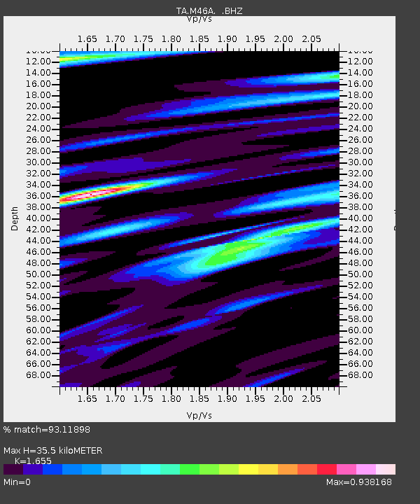
| Estimated Moho Depth: |
35.5 km |
| Estimated Crust Vp/Vs: |
1.65 |
| Assumed Crust Vp: |
6.498 km/s |
| Estimated Crust Vs: |
3.926 km/s |
| Estimated Crust Poisson's Ratio: |
0.21 |
|
| Radial Match: |
93.11898 % |
| Radial Bump: |
400 |
| Transverse Match: |
81.21531 % |
| Transverse Bump: |
400 |
| SOD ConfigId: |
494114 |
| Insert Time: |
2013-04-27 04:04:17.347 +0000 |
| GWidth: |
2.5 |
| Max Bumps: |
400 |
| Tol: |
0.001 |
|
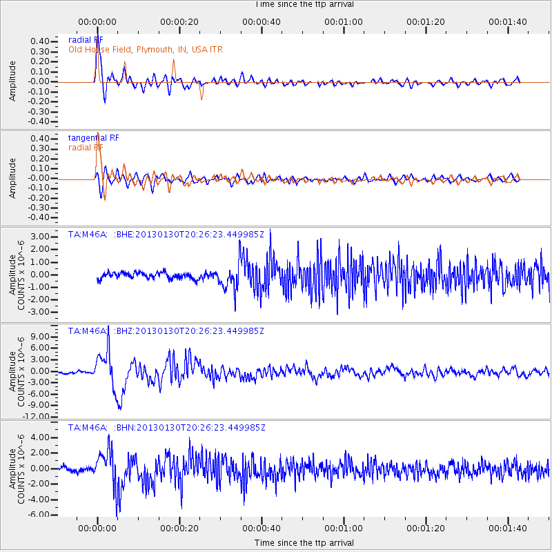
Signal To Noise
| Channel | StoN | STA | LTA |
| TA:M46A: :BHZ:20130130T20:26:23.449985Z | 19.79635 | 4.9178875E-6 | 2.4842396E-7 |
| TA:M46A: :BHN:20130130T20:26:23.449985Z | 9.5114155 | 2.3920131E-6 | 2.5148867E-7 |
| TA:M46A: :BHE:20130130T20:26:23.449985Z | 4.7016683 | 1.1219178E-6 | 2.386212E-7 |
| Arrivals |
| Ps | 3.7 SECOND |
| PpPs | 14 SECOND |
| PsPs/PpSs | 18 SECOND |


