You are here: Home > Network List > TA - USArray Transportable Network (new EarthScope stations) Stations List
> Station T47A Sharon Grove, KY, USA > Earthquake Result Viewer
T47A Sharon Grove, KY, USA - Earthquake Result Viewer
| Earthquake location: |
Central Chile |
| Earthquake latitude/longitude: |
-28.1/-70.7 |
| Earthquake time(UTC): |
2013/01/30 (030) 20:15:43 GMT |
| Earthquake Depth: |
45 km |
| Earthquake Magnitude: |
6.5 MB, 6.5 MS, 6.8 MW, 6.8 MW |
| Earthquake Catalog/Contributor: |
WHDF/NEIC |
|
| Network: |
TA USArray Transportable Network (new EarthScope stations) |
| Station: |
T47A Sharon Grove, KY, USA |
| Lat/Lon: |
36.99 N/87.11 W |
| Elevation: |
217 m |
|
| Distance: |
66.6 deg |
| Az: |
345.69 deg |
| Baz: |
164.173 deg |
| Ray Param: |
0.05744667 |
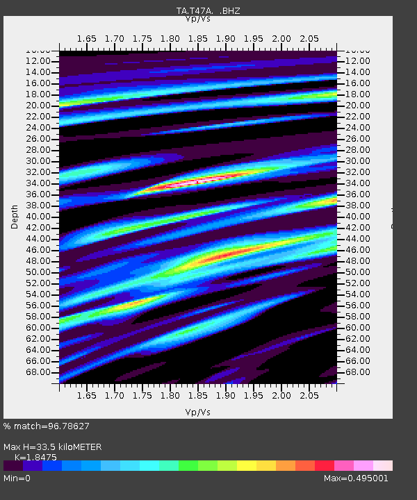
| Estimated Moho Depth: |
33.5 km |
| Estimated Crust Vp/Vs: |
1.85 |
| Assumed Crust Vp: |
6.444 km/s |
| Estimated Crust Vs: |
3.488 km/s |
| Estimated Crust Poisson's Ratio: |
0.29 |
|
| Radial Match: |
96.78627 % |
| Radial Bump: |
260 |
| Transverse Match: |
97.84578 % |
| Transverse Bump: |
162 |
| SOD ConfigId: |
494114 |
| Insert Time: |
2013-04-27 04:05:00.417 +0000 |
| GWidth: |
2.5 |
| Max Bumps: |
400 |
| Tol: |
0.001 |
|
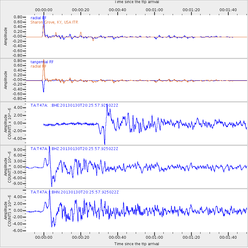
Signal To Noise
| Channel | StoN | STA | LTA |
| TA:T47A: :BHZ:20130130T20:25:57.925022Z | 16.087769 | 4.8257402E-6 | 2.9996332E-7 |
| TA:T47A: :BHN:20130130T20:25:57.925022Z | 5.85375 | 2.5111622E-6 | 4.2898347E-7 |
| TA:T47A: :BHE:20130130T20:25:57.925022Z | 14.134844 | 2.3504815E-6 | 1.6628988E-7 |
| Arrivals |
| Ps | 4.6 SECOND |
| PpPs | 14 SECOND |
| PsPs/PpSs | 19 SECOND |


