You are here: Home > Network List > TA - USArray Transportable Network (new EarthScope stations) Stations List
> Station S46A Don Dixon Farm, Corydon, KY, USA > Earthquake Result Viewer
S46A Don Dixon Farm, Corydon, KY, USA - Earthquake Result Viewer
| Earthquake location: |
Central Chile |
| Earthquake latitude/longitude: |
-28.1/-70.7 |
| Earthquake time(UTC): |
2013/01/30 (030) 20:15:43 GMT |
| Earthquake Depth: |
45 km |
| Earthquake Magnitude: |
6.5 MB, 6.5 MS, 6.8 MW, 6.8 MW |
| Earthquake Catalog/Contributor: |
WHDF/NEIC |
|
| Network: |
TA USArray Transportable Network (new EarthScope stations) |
| Station: |
S46A Don Dixon Farm, Corydon, KY, USA |
| Lat/Lon: |
37.68 N/87.72 W |
| Elevation: |
125 m |
|
| Distance: |
67.4 deg |
| Az: |
345.391 deg |
| Baz: |
163.688 deg |
| Ray Param: |
0.056919187 |
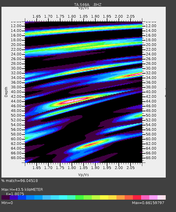
| Estimated Moho Depth: |
43.5 km |
| Estimated Crust Vp/Vs: |
1.81 |
| Assumed Crust Vp: |
6.444 km/s |
| Estimated Crust Vs: |
3.565 km/s |
| Estimated Crust Poisson's Ratio: |
0.28 |
|
| Radial Match: |
96.04518 % |
| Radial Bump: |
400 |
| Transverse Match: |
85.84978 % |
| Transverse Bump: |
400 |
| SOD ConfigId: |
494114 |
| Insert Time: |
2013-04-27 04:05:05.935 +0000 |
| GWidth: |
2.5 |
| Max Bumps: |
400 |
| Tol: |
0.001 |
|

Signal To Noise
| Channel | StoN | STA | LTA |
| TA:S46A: :BHZ:20130130T20:26:03.024998Z | 54.629826 | 5.9456816E-6 | 1.0883581E-7 |
| TA:S46A: :BHN:20130130T20:26:03.024998Z | 12.66317 | 2.3695604E-6 | 1.8712221E-7 |
| TA:S46A: :BHE:20130130T20:26:03.024998Z | 4.513887 | 1.0820871E-6 | 2.3972405E-7 |
| Arrivals |
| Ps | 5.7 SECOND |
| PpPs | 18 SECOND |
| PsPs/PpSs | 24 SECOND |


