You are here: Home > Network List > TA - USArray Transportable Network (new EarthScope stations) Stations List
> Station X46A Booneville, MS, USA > Earthquake Result Viewer
X46A Booneville, MS, USA - Earthquake Result Viewer
| Earthquake location: |
Central Chile |
| Earthquake latitude/longitude: |
-28.1/-70.7 |
| Earthquake time(UTC): |
2013/01/30 (030) 20:15:43 GMT |
| Earthquake Depth: |
45 km |
| Earthquake Magnitude: |
6.5 MB, 6.5 MS, 6.8 MW, 6.8 MW |
| Earthquake Catalog/Contributor: |
WHDF/NEIC |
|
| Network: |
TA USArray Transportable Network (new EarthScope stations) |
| Station: |
X46A Booneville, MS, USA |
| Lat/Lon: |
34.56 N/88.58 W |
| Elevation: |
150 m |
|
| Distance: |
64.6 deg |
| Az: |
343.66 deg |
| Baz: |
162.473 deg |
| Ray Param: |
0.058742713 |
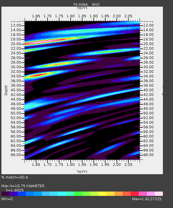
| Estimated Moho Depth: |
18.75 km |
| Estimated Crust Vp/Vs: |
1.68 |
| Assumed Crust Vp: |
6.38 km/s |
| Estimated Crust Vs: |
3.792 km/s |
| Estimated Crust Poisson's Ratio: |
0.23 |
|
| Radial Match: |
80.6 % |
| Radial Bump: |
400 |
| Transverse Match: |
59.71022 % |
| Transverse Bump: |
400 |
| SOD ConfigId: |
494114 |
| Insert Time: |
2013-04-27 04:05:22.725 +0000 |
| GWidth: |
2.5 |
| Max Bumps: |
400 |
| Tol: |
0.001 |
|
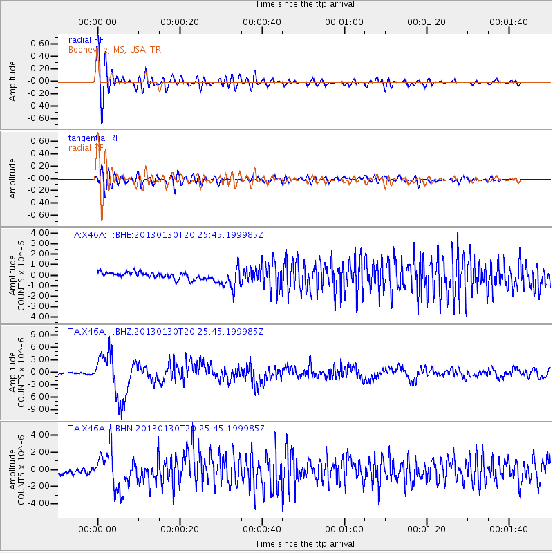
Signal To Noise
| Channel | StoN | STA | LTA |
| TA:X46A: :BHZ:20130130T20:25:45.199985Z | 22.577509 | 4.23517E-6 | 1.8758357E-7 |
| TA:X46A: :BHN:20130130T20:25:45.199985Z | 7.0045 | 2.1992985E-6 | 3.1398366E-7 |
| TA:X46A: :BHE:20130130T20:25:45.199985Z | 3.480371 | 1.0492523E-6 | 3.0147714E-7 |
| Arrivals |
| Ps | 2.1 SECOND |
| PpPs | 7.5 SECOND |
| PsPs/PpSs | 9.6 SECOND |


