You are here: Home > Network List > TA - USArray Transportable Network (new EarthScope stations) Stations List
> Station X49A Woodville, AR, USA > Earthquake Result Viewer
X49A Woodville, AR, USA - Earthquake Result Viewer

| Earthquake location: |
Central Chile |
| Earthquake latitude/longitude: |
-28.1/-70.7 |
| Earthquake time(UTC): |
2013/01/30 (030) 20:15:43 GMT |
| Earthquake Depth: |
45 km |
| Earthquake Magnitude: |
6.5 MB, 6.5 MS, 6.8 MW, 6.8 MW |
| Earthquake Catalog/Contributor: |
WHDF/NEIC |
|
| Network: |
TA USArray Transportable Network (new EarthScope stations) |
| Station: |
X49A Woodville, AR, USA |
| Lat/Lon: |
34.51 N/86.33 W |
| Elevation: |
182 m |
|
| Distance: |
64.0 deg |
| Az: |
345.63 deg |
| Baz: |
164.602 deg |
| Ray Param: |
0.059109647 |
| Estimated Moho Depth: |
42.0 km |
| Estimated Crust Vp/Vs: |
1.94 |
| Assumed Crust Vp: |
6.476 km/s |
| Estimated Crust Vs: |
3.342 km/s |
| Estimated Crust Poisson's Ratio: |
0.32 |
|
| Radial Match: |
95.73677 % |
| Radial Bump: |
330 |
| Transverse Match: |
85.54449 % |
| Transverse Bump: |
400 |
| SOD ConfigId: |
494114 |
| Insert Time: |
2013-04-27 04:05:40.283 +0000 |
| GWidth: |
2.5 |
| Max Bumps: |
400 |
| Tol: |
0.001 |
|
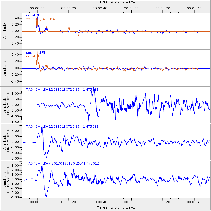
Signal To Noise
| Channel | StoN | STA | LTA |
| TA:X49A: :BHZ:20130130T20:25:41.47501Z | 23.86503 | 4.569887E-6 | 1.9148885E-7 |
| TA:X49A: :BHN:20130130T20:25:41.47501Z | 11.209182 | 1.7368384E-6 | 1.5494783E-7 |
| TA:X49A: :BHE:20130130T20:25:41.47501Z | 5.5480814 | 6.642931E-7 | 1.1973384E-7 |
| Arrivals |
| Ps | 6.3 SECOND |
| PpPs | 18 SECOND |
| PsPs/PpSs | 25 SECOND |


