You are here: Home > Network List > TA - USArray Transportable Network (new EarthScope stations) Stations List
> Station X48A Hartselle, AL, USA > Earthquake Result Viewer
X48A Hartselle, AL, USA - Earthquake Result Viewer
| Earthquake location: |
Central Chile |
| Earthquake latitude/longitude: |
-28.1/-70.7 |
| Earthquake time(UTC): |
2013/01/30 (030) 20:15:43 GMT |
| Earthquake Depth: |
45 km |
| Earthquake Magnitude: |
6.5 MB, 6.5 MS, 6.8 MW, 6.8 MW |
| Earthquake Catalog/Contributor: |
WHDF/NEIC |
|
| Network: |
TA USArray Transportable Network (new EarthScope stations) |
| Station: |
X48A Hartselle, AL, USA |
| Lat/Lon: |
34.45 N/87.05 W |
| Elevation: |
180 m |
|
| Distance: |
64.1 deg |
| Az: |
344.976 deg |
| Baz: |
163.91 deg |
| Ray Param: |
0.059041623 |
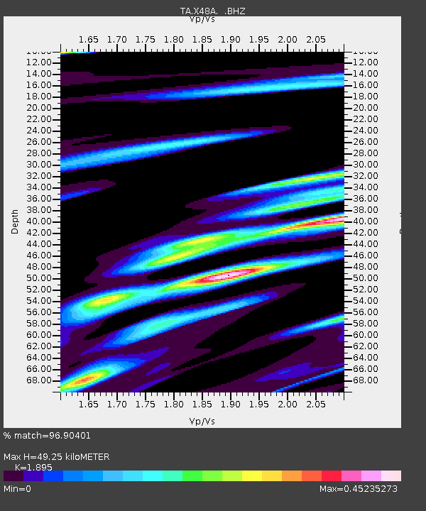
| Estimated Moho Depth: |
49.25 km |
| Estimated Crust Vp/Vs: |
1.89 |
| Assumed Crust Vp: |
6.476 km/s |
| Estimated Crust Vs: |
3.417 km/s |
| Estimated Crust Poisson's Ratio: |
0.31 |
|
| Radial Match: |
96.90401 % |
| Radial Bump: |
345 |
| Transverse Match: |
96.82829 % |
| Transverse Bump: |
307 |
| SOD ConfigId: |
494114 |
| Insert Time: |
2013-04-27 04:05:49.894 +0000 |
| GWidth: |
2.5 |
| Max Bumps: |
400 |
| Tol: |
0.001 |
|
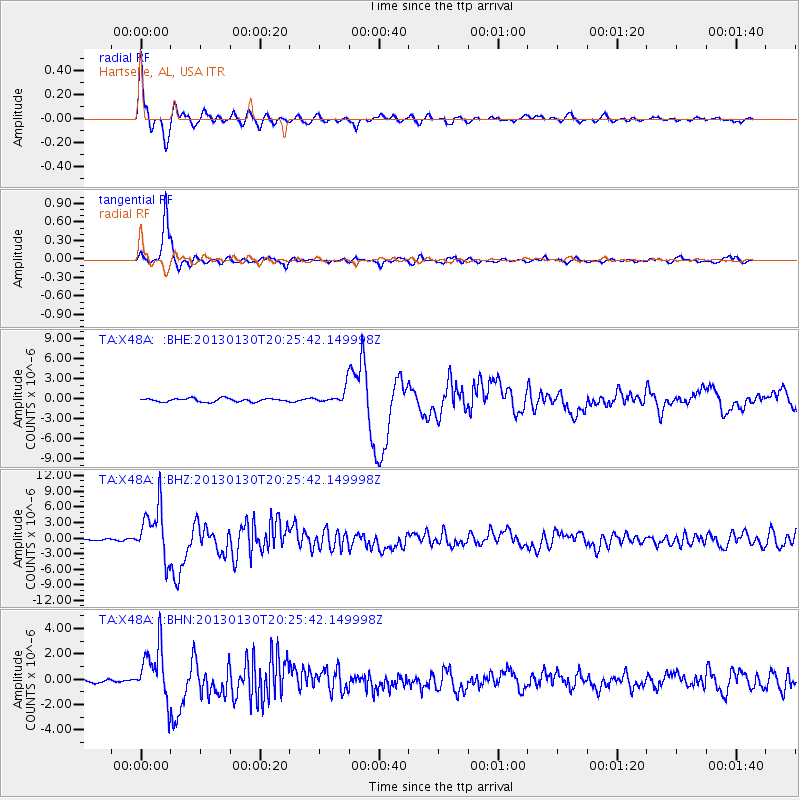
Signal To Noise
| Channel | StoN | STA | LTA |
| TA:X48A: :BHZ:20130130T20:25:42.149998Z | 25.524975 | 4.969738E-6 | 1.94701E-7 |
| TA:X48A: :BHN:20130130T20:25:42.149998Z | 13.610385 | 2.1071808E-6 | 1.5482154E-7 |
| TA:X48A: :BHE:20130130T20:25:42.149998Z | 4.639391 | 1.1827093E-6 | 2.549277E-7 |
| Arrivals |
| Ps | 7.1 SECOND |
| PpPs | 21 SECOND |
| PsPs/PpSs | 28 SECOND |


