You are here: Home > Network List > TA - USArray Transportable Network (new EarthScope stations) Stations List
> Station Z49A Columbiana, AL, USA > Earthquake Result Viewer
Z49A Columbiana, AL, USA - Earthquake Result Viewer
| Earthquake location: |
Central Chile |
| Earthquake latitude/longitude: |
-28.1/-70.7 |
| Earthquake time(UTC): |
2013/01/30 (030) 20:15:43 GMT |
| Earthquake Depth: |
45 km |
| Earthquake Magnitude: |
6.5 MB, 6.5 MS, 6.8 MW, 6.8 MW |
| Earthquake Catalog/Contributor: |
WHDF/NEIC |
|
| Network: |
TA USArray Transportable Network (new EarthScope stations) |
| Station: |
Z49A Columbiana, AL, USA |
| Lat/Lon: |
33.19 N/86.53 W |
| Elevation: |
134 m |
|
| Distance: |
62.8 deg |
| Az: |
345.051 deg |
| Baz: |
164.229 deg |
| Ray Param: |
0.059905834 |
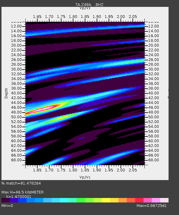
| Estimated Moho Depth: |
46.5 km |
| Estimated Crust Vp/Vs: |
1.67 |
| Assumed Crust Vp: |
6.565 km/s |
| Estimated Crust Vs: |
3.931 km/s |
| Estimated Crust Poisson's Ratio: |
0.22 |
|
| Radial Match: |
91.478264 % |
| Radial Bump: |
400 |
| Transverse Match: |
78.31151 % |
| Transverse Bump: |
400 |
| SOD ConfigId: |
494114 |
| Insert Time: |
2013-04-27 04:06:01.520 +0000 |
| GWidth: |
2.5 |
| Max Bumps: |
400 |
| Tol: |
0.001 |
|
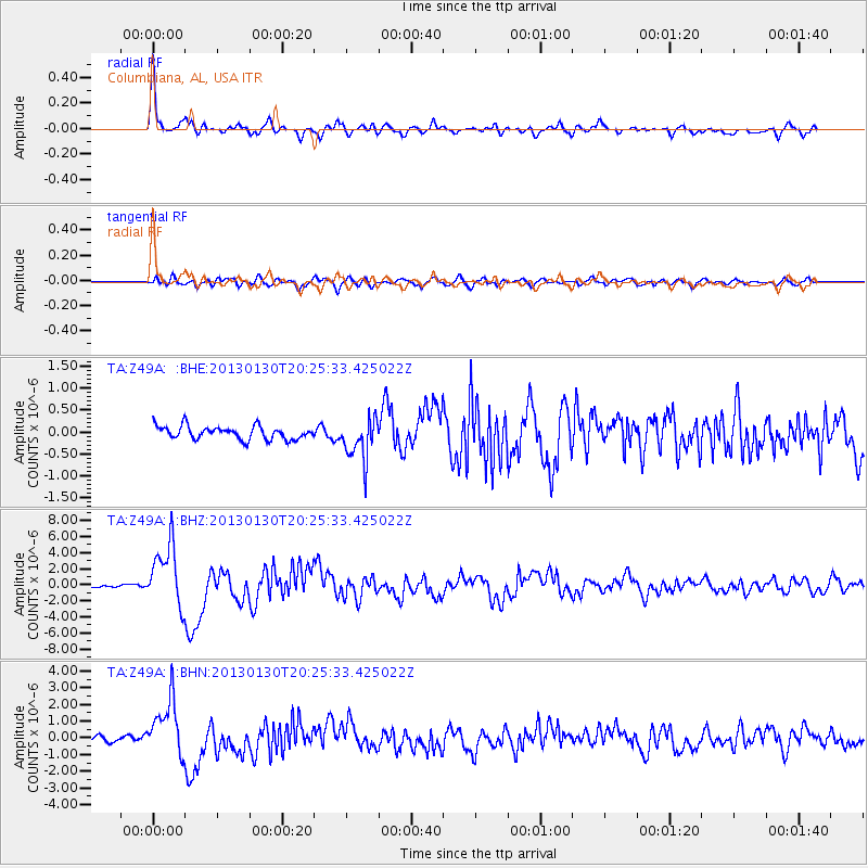
Signal To Noise
| Channel | StoN | STA | LTA |
| TA:Z49A: :BHZ:20130130T20:25:33.425022Z | 26.522875 | 3.836525E-6 | 1.4464968E-7 |
| TA:Z49A: :BHN:20130130T20:25:33.425022Z | 10.41318 | 1.7123778E-6 | 1.644433E-7 |
| TA:Z49A: :BHE:20130130T20:25:33.425022Z | 3.186288 | 4.7368863E-7 | 1.4866471E-7 |
| Arrivals |
| Ps | 5.0 SECOND |
| PpPs | 18 SECOND |
| PsPs/PpSs | 23 SECOND |


