You are here: Home > Network List > TA - USArray Transportable Network (new EarthScope stations) Stations List
> Station W46A Michie, TN, USA > Earthquake Result Viewer
W46A Michie, TN, USA - Earthquake Result Viewer
| Earthquake location: |
Central Chile |
| Earthquake latitude/longitude: |
-28.1/-70.7 |
| Earthquake time(UTC): |
2013/01/30 (030) 20:15:43 GMT |
| Earthquake Depth: |
45 km |
| Earthquake Magnitude: |
6.5 MB, 6.5 MS, 6.8 MW, 6.8 MW |
| Earthquake Catalog/Contributor: |
WHDF/NEIC |
|
| Network: |
TA USArray Transportable Network (new EarthScope stations) |
| Station: |
W46A Michie, TN, USA |
| Lat/Lon: |
35.13 N/88.38 W |
| Elevation: |
145 m |
|
| Distance: |
65.1 deg |
| Az: |
344.028 deg |
| Baz: |
162.747 deg |
| Ray Param: |
0.0584179 |
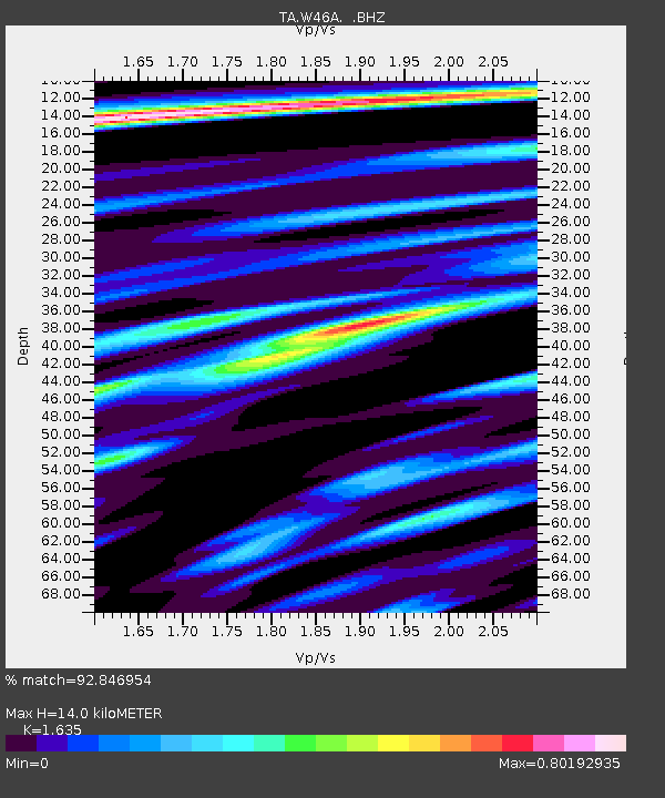
| Estimated Moho Depth: |
14.0 km |
| Estimated Crust Vp/Vs: |
1.63 |
| Assumed Crust Vp: |
6.38 km/s |
| Estimated Crust Vs: |
3.902 km/s |
| Estimated Crust Poisson's Ratio: |
0.20 |
|
| Radial Match: |
92.846954 % |
| Radial Bump: |
400 |
| Transverse Match: |
85.819374 % |
| Transverse Bump: |
400 |
| SOD ConfigId: |
494114 |
| Insert Time: |
2013-04-27 04:06:25.035 +0000 |
| GWidth: |
2.5 |
| Max Bumps: |
400 |
| Tol: |
0.001 |
|
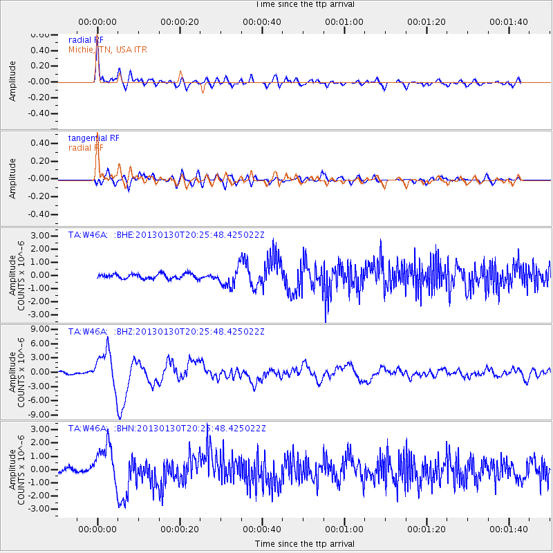
Signal To Noise
| Channel | StoN | STA | LTA |
| TA:W46A: :BHZ:20130130T20:25:48.425022Z | 18.288551 | 4.0030777E-6 | 2.1888435E-7 |
| TA:W46A: :BHN:20130130T20:25:48.425022Z | 10.108398 | 1.5294739E-6 | 1.5130725E-7 |
| TA:W46A: :BHE:20130130T20:25:48.425022Z | 3.9394205 | 7.398476E-7 | 1.8780621E-7 |
| Arrivals |
| Ps | 1.5 SECOND |
| PpPs | 5.5 SECOND |
| PsPs/PpSs | 7.0 SECOND |


