You are here: Home > Network List > TA - USArray Transportable Network (new EarthScope stations) Stations List
> Station W47A Westpoint, TN, USA > Earthquake Result Viewer
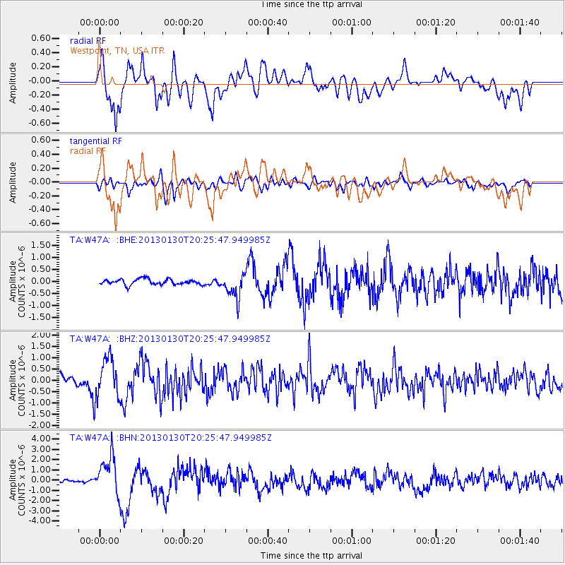
W47A Westpoint, TN, USA - Earthquake Result Viewer
*The percent match for this event was below the threshold and hence no stack was calculated.
| Earthquake location: |
Central Chile |
| Earthquake latitude/longitude: |
-28.1/-70.7 |
| Earthquake time(UTC): |
2013/01/30 (030) 20:15:43 GMT |
| Earthquake Depth: |
45 km |
| Earthquake Magnitude: |
6.5 MB, 6.5 MS, 6.8 MW, 6.8 MW |
| Earthquake Catalog/Contributor: |
WHDF/NEIC |
|
| Network: |
TA USArray Transportable Network (new EarthScope stations) |
| Station: |
W47A Westpoint, TN, USA |
| Lat/Lon: |
35.25 N/87.59 W |
| Elevation: |
293 m |
|
| Distance: |
65.0 deg |
| Az: |
344.744 deg |
| Baz: |
163.498 deg |
| Ray Param: |
$rayparam |
*The percent match for this event was below the threshold and hence was not used in the summary stack. |
|
| Radial Match: |
68.128975 % |
| Radial Bump: |
400 |
| Transverse Match: |
60.627266 % |
| Transverse Bump: |
400 |
| SOD ConfigId: |
494114 |
| Insert Time: |
2013-04-27 04:07:19.429 +0000 |
| GWidth: |
2.5 |
| Max Bumps: |
400 |
| Tol: |
0.001 |
|
Signal To Noise
| Channel | StoN | STA | LTA |
| TA:W47A: :BHZ:20130130T20:25:47.949985Z | 3.7439952 | 8.317643E-7 | 2.2215956E-7 |
| TA:W47A: :BHN:20130130T20:25:47.949985Z | 12.973099 | 1.8628385E-6 | 1.4359242E-7 |
| TA:W47A: :BHE:20130130T20:25:47.949985Z | 4.550563 | 5.2633465E-7 | 1.1566364E-7 |
| Arrivals |
| Ps | |
| PpPs | |
| PsPs/PpSs | |


