You are here: Home > Network List > TA - USArray Transportable Network (new EarthScope stations) Stations List
> Station 154A Montrose, GA, USA > Earthquake Result Viewer
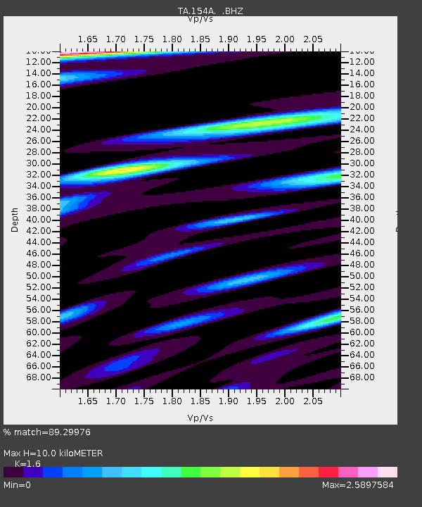
154A Montrose, GA, USA - Earthquake Result Viewer
| Earthquake location: |
Central Chile |
| Earthquake latitude/longitude: |
-28.1/-70.7 |
| Earthquake time(UTC): |
2013/01/30 (030) 20:15:43 GMT |
| Earthquake Depth: |
45 km |
| Earthquake Magnitude: |
6.5 MB, 6.5 MS, 6.8 MW, 6.8 MW |
| Earthquake Catalog/Contributor: |
WHDF/NEIC |
|
| Network: |
TA USArray Transportable Network (new EarthScope stations) |
| Station: |
154A Montrose, GA, USA |
| Lat/Lon: |
32.61 N/83.11 W |
| Elevation: |
111 m |
|
| Distance: |
61.5 deg |
| Az: |
348.05 deg |
| Baz: |
167.482 deg |
| Ray Param: |
0.060728315 |
| Estimated Moho Depth: |
10.0 km |
| Estimated Crust Vp/Vs: |
1.60 |
| Assumed Crust Vp: |
6.565 km/s |
| Estimated Crust Vs: |
4.103 km/s |
| Estimated Crust Poisson's Ratio: |
0.18 |
|
| Radial Match: |
89.29976 % |
| Radial Bump: |
400 |
| Transverse Match: |
77.49566 % |
| Transverse Bump: |
400 |
| SOD ConfigId: |
494114 |
| Insert Time: |
2013-04-27 04:10:21.117 +0000 |
| GWidth: |
2.5 |
| Max Bumps: |
400 |
| Tol: |
0.001 |
|

Signal To Noise
| Channel | StoN | STA | LTA |
| TA:154A: :BHZ:20130130T20:25:24.97501Z | 23.065271 | 5.413583E-6 | 2.3470712E-7 |
| TA:154A: :BHN:20130130T20:25:24.97501Z | 5.859347 | 2.8785926E-6 | 4.9128215E-7 |
| TA:154A: :BHE:20130130T20:25:24.97501Z | 1.4232528 | 6.465412E-7 | 4.5427007E-7 |
| Arrivals |
| Ps | 1.0 SECOND |
| PpPs | 3.8 SECOND |
| PsPs/PpSs | 4.7 SECOND |


