You are here: Home > Network List > TA - USArray Transportable Network (new EarthScope stations) Stations List
> Station X52A Dahlonega, GA, USA > Earthquake Result Viewer
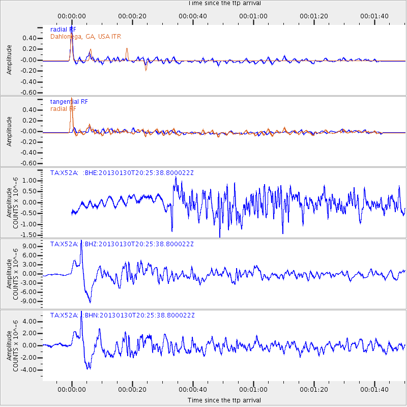
X52A Dahlonega, GA, USA - Earthquake Result Viewer

| Earthquake location: |
Central Chile |
| Earthquake latitude/longitude: |
-28.1/-70.7 |
| Earthquake time(UTC): |
2013/01/30 (030) 20:15:43 GMT |
| Earthquake Depth: |
45 km |
| Earthquake Magnitude: |
6.5 MB, 6.5 MS, 6.8 MW, 6.8 MW |
| Earthquake Catalog/Contributor: |
WHDF/NEIC |
|
| Network: |
TA USArray Transportable Network (new EarthScope stations) |
| Station: |
X52A Dahlonega, GA, USA |
| Lat/Lon: |
34.60 N/83.89 W |
| Elevation: |
481 m |
|
| Distance: |
63.6 deg |
| Az: |
347.823 deg |
| Baz: |
166.944 deg |
| Ray Param: |
0.05937834 |
| Estimated Moho Depth: |
33.75 km |
| Estimated Crust Vp/Vs: |
1.97 |
| Assumed Crust Vp: |
6.35 km/s |
| Estimated Crust Vs: |
3.232 km/s |
| Estimated Crust Poisson's Ratio: |
0.33 |
|
| Radial Match: |
94.81403 % |
| Radial Bump: |
400 |
| Transverse Match: |
64.105515 % |
| Transverse Bump: |
400 |
| SOD ConfigId: |
494114 |
| Insert Time: |
2013-04-27 04:10:50.721 +0000 |
| GWidth: |
2.5 |
| Max Bumps: |
400 |
| Tol: |
0.001 |
|
Signal To Noise
| Channel | StoN | STA | LTA |
| TA:X52A: :BHZ:20130130T20:25:38.800022Z | 21.728033 | 4.3975992E-6 | 2.0239287E-7 |
| TA:X52A: :BHN:20130130T20:25:38.800022Z | 10.032227 | 2.2602494E-6 | 2.2529888E-7 |
| TA:X52A: :BHE:20130130T20:25:38.800022Z | 2.427082 | 5.2855484E-7 | 2.1777377E-7 |
| Arrivals |
| Ps | 5.3 SECOND |
| PpPs | 15 SECOND |
| PsPs/PpSs | 20 SECOND |


