You are here: Home > Network List > TA - USArray Transportable Network (new EarthScope stations) Stations List
> Station V50A Pikevile, TN, USA > Earthquake Result Viewer
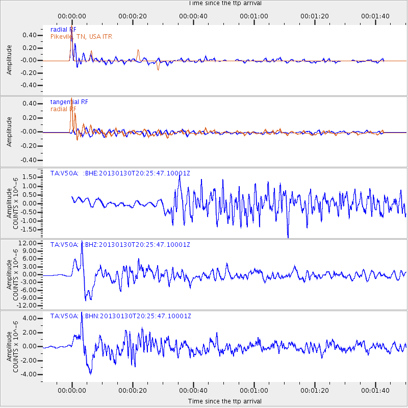
V50A Pikevile, TN, USA - Earthquake Result Viewer

| Earthquake location: |
Central Chile |
| Earthquake latitude/longitude: |
-28.1/-70.7 |
| Earthquake time(UTC): |
2013/01/30 (030) 20:15:43 GMT |
| Earthquake Depth: |
45 km |
| Earthquake Magnitude: |
6.5 MB, 6.5 MS, 6.8 MW, 6.8 MW |
| Earthquake Catalog/Contributor: |
WHDF/NEIC |
|
| Network: |
TA USArray Transportable Network (new EarthScope stations) |
| Station: |
V50A Pikevile, TN, USA |
| Lat/Lon: |
35.67 N/85.10 W |
| Elevation: |
287 m |
|
| Distance: |
64.9 deg |
| Az: |
347.034 deg |
| Baz: |
165.909 deg |
| Ray Param: |
0.058553465 |
| Estimated Moho Depth: |
10.0 km |
| Estimated Crust Vp/Vs: |
1.60 |
| Assumed Crust Vp: |
6.35 km/s |
| Estimated Crust Vs: |
3.969 km/s |
| Estimated Crust Poisson's Ratio: |
0.18 |
|
| Radial Match: |
93.73411 % |
| Radial Bump: |
400 |
| Transverse Match: |
82.13946 % |
| Transverse Bump: |
400 |
| SOD ConfigId: |
494114 |
| Insert Time: |
2013-04-27 04:11:47.432 +0000 |
| GWidth: |
2.5 |
| Max Bumps: |
400 |
| Tol: |
0.001 |
|
Signal To Noise
| Channel | StoN | STA | LTA |
| TA:V50A: :BHZ:20130130T20:25:47.10001Z | 24.241308 | 5.424856E-6 | 2.2378563E-7 |
| TA:V50A: :BHN:20130130T20:25:47.10001Z | 9.844957 | 1.7684981E-6 | 1.7963492E-7 |
| TA:V50A: :BHE:20130130T20:25:47.10001Z | 3.28801 | 5.235307E-7 | 1.5922417E-7 |
| Arrivals |
| Ps | 1.0 SECOND |
| PpPs | 3.9 SECOND |
| PsPs/PpSs | 4.9 SECOND |


