You are here: Home > Network List > TA - USArray Transportable Network (new EarthScope stations) Stations List
> Station T50A Nancy, KY, USA > Earthquake Result Viewer
T50A Nancy, KY, USA - Earthquake Result Viewer
| Earthquake location: |
Central Chile |
| Earthquake latitude/longitude: |
-28.1/-70.7 |
| Earthquake time(UTC): |
2013/01/30 (030) 20:15:43 GMT |
| Earthquake Depth: |
45 km |
| Earthquake Magnitude: |
6.5 MB, 6.5 MS, 6.8 MW, 6.8 MW |
| Earthquake Catalog/Contributor: |
WHDF/NEIC |
|
| Network: |
TA USArray Transportable Network (new EarthScope stations) |
| Station: |
T50A Nancy, KY, USA |
| Lat/Lon: |
37.02 N/84.84 W |
| Elevation: |
302 m |
|
| Distance: |
66.1 deg |
| Az: |
347.615 deg |
| Baz: |
166.305 deg |
| Ray Param: |
0.057730727 |
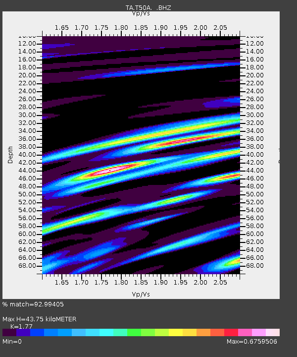
| Estimated Moho Depth: |
43.75 km |
| Estimated Crust Vp/Vs: |
1.77 |
| Assumed Crust Vp: |
6.476 km/s |
| Estimated Crust Vs: |
3.659 km/s |
| Estimated Crust Poisson's Ratio: |
0.27 |
|
| Radial Match: |
92.99405 % |
| Radial Bump: |
370 |
| Transverse Match: |
78.251686 % |
| Transverse Bump: |
400 |
| SOD ConfigId: |
494114 |
| Insert Time: |
2013-04-27 04:13:02.401 +0000 |
| GWidth: |
2.5 |
| Max Bumps: |
400 |
| Tol: |
0.001 |
|
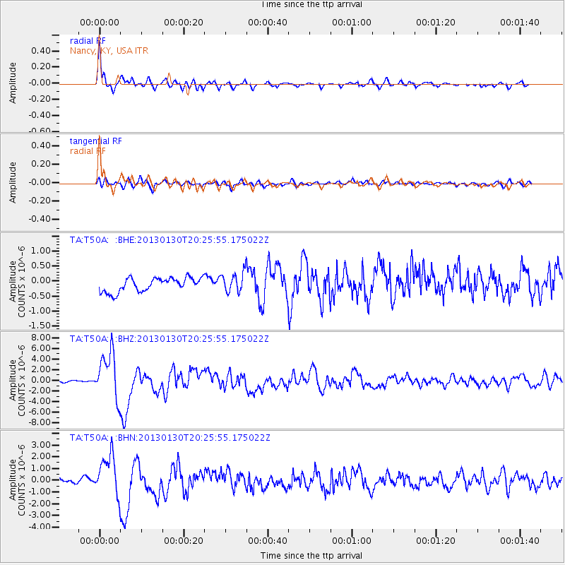
Signal To Noise
| Channel | StoN | STA | LTA |
| TA:T50A: :BHZ:20130130T20:25:55.175022Z | 22.229568 | 4.447162E-6 | 2.0005616E-7 |
| TA:T50A: :BHN:20130130T20:25:55.175022Z | 6.7156935 | 1.8318733E-6 | 2.72775E-7 |
| TA:T50A: :BHE:20130130T20:25:55.175022Z | 1.490495 | 3.4152617E-7 | 2.2913608E-7 |
| Arrivals |
| Ps | 5.4 SECOND |
| PpPs | 18 SECOND |
| PsPs/PpSs | 23 SECOND |


