You are here: Home > Network List > TA - USArray Transportable Network (new EarthScope stations) Stations List
> Station M48A Edgerton, OH, USA > Earthquake Result Viewer
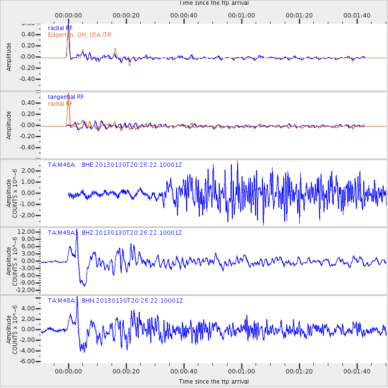
M48A Edgerton, OH, USA - Earthquake Result Viewer

| Earthquake location: |
Central Chile |
| Earthquake latitude/longitude: |
-28.1/-70.7 |
| Earthquake time(UTC): |
2013/01/30 (030) 20:15:43 GMT |
| Earthquake Depth: |
45 km |
| Earthquake Magnitude: |
6.5 MB, 6.5 MS, 6.8 MW, 6.8 MW |
| Earthquake Catalog/Contributor: |
WHDF/NEIC |
|
| Network: |
TA USArray Transportable Network (new EarthScope stations) |
| Station: |
M48A Edgerton, OH, USA |
| Lat/Lon: |
41.48 N/84.72 W |
| Elevation: |
258 m |
|
| Distance: |
70.4 deg |
| Az: |
348.828 deg |
| Baz: |
166.83 deg |
| Ray Param: |
0.054895557 |
| Estimated Moho Depth: |
30.0 km |
| Estimated Crust Vp/Vs: |
2.05 |
| Assumed Crust Vp: |
6.498 km/s |
| Estimated Crust Vs: |
3.177 km/s |
| Estimated Crust Poisson's Ratio: |
0.34 |
|
| Radial Match: |
94.94777 % |
| Radial Bump: |
359 |
| Transverse Match: |
83.20676 % |
| Transverse Bump: |
400 |
| SOD ConfigId: |
494114 |
| Insert Time: |
2013-04-27 04:14:47.425 +0000 |
| GWidth: |
2.5 |
| Max Bumps: |
400 |
| Tol: |
0.001 |
|
Signal To Noise
| Channel | StoN | STA | LTA |
| TA:M48A: :BHZ:20130130T20:26:22.10001Z | 27.903324 | 5.7689954E-6 | 2.0674939E-7 |
| TA:M48A: :BHN:20130130T20:26:22.10001Z | 10.972198 | 2.5171155E-6 | 2.2940851E-7 |
| TA:M48A: :BHE:20130130T20:26:22.10001Z | 2.3655005 | 4.7302638E-7 | 1.9996882E-7 |
| Arrivals |
| Ps | 5.0 SECOND |
| PpPs | 14 SECOND |
| PsPs/PpSs | 19 SECOND |


