You are here: Home > Network List > TA - USArray Transportable Network (new EarthScope stations) Stations List
> Station P53A Whipple, OH, USA > Earthquake Result Viewer
P53A Whipple, OH, USA - Earthquake Result Viewer
| Earthquake location: |
Central Chile |
| Earthquake latitude/longitude: |
-28.1/-70.7 |
| Earthquake time(UTC): |
2013/01/30 (030) 20:15:43 GMT |
| Earthquake Depth: |
45 km |
| Earthquake Magnitude: |
6.5 MB, 6.5 MS, 6.8 MW, 6.8 MW |
| Earthquake Catalog/Contributor: |
WHDF/NEIC |
|
| Network: |
TA USArray Transportable Network (new EarthScope stations) |
| Station: |
P53A Whipple, OH, USA |
| Lat/Lon: |
39.49 N/81.39 W |
| Elevation: |
270 m |
|
| Distance: |
68.0 deg |
| Az: |
351.053 deg |
| Baz: |
169.773 deg |
| Ray Param: |
0.056521088 |
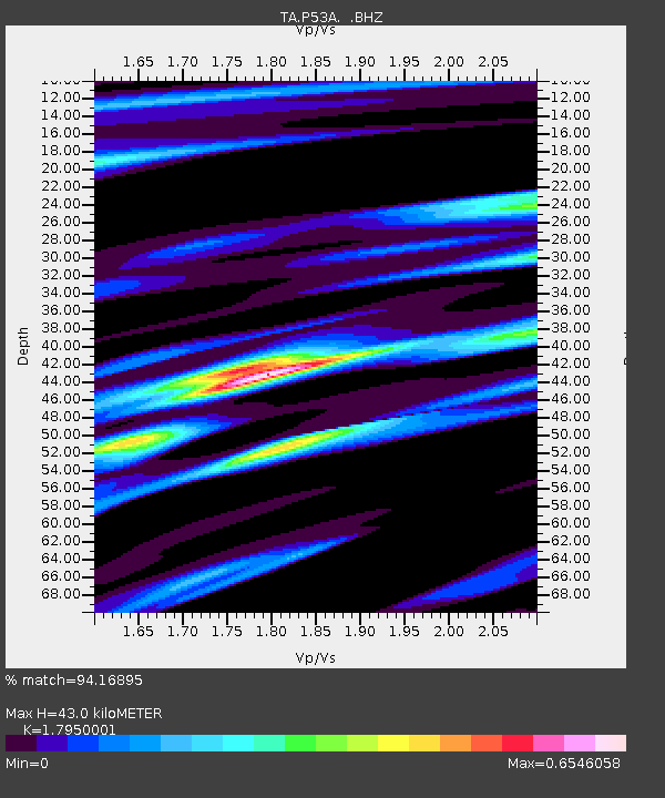
| Estimated Moho Depth: |
43.0 km |
| Estimated Crust Vp/Vs: |
1.80 |
| Assumed Crust Vp: |
6.207 km/s |
| Estimated Crust Vs: |
3.458 km/s |
| Estimated Crust Poisson's Ratio: |
0.27 |
|
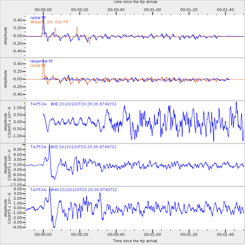
| Radial Match: |
94.16895 % |
| Radial Bump: |
368 |
| Transverse Match: |
82.61723 % |
| Transverse Bump: |
400 |
| SOD ConfigId: |
494114 |
| Insert Time: |
2013-04-27 04:15:27.489 +0000 |
| GWidth: |
2.5 |
| Max Bumps: |
400 |
| Tol: |
0.001 |
|
Signal To Noise
| Channel | StoN | STA | LTA |
| TA:P53A: :BHZ:20130130T20:26:06.874973Z | 18.530275 | 4.8957195E-6 | 2.642011E-7 |
| TA:P53A: :BHN:20130130T20:26:06.874973Z | 10.513458 | 1.952025E-6 | 1.8566917E-7 |
| TA:P53A: :BHE:20130130T20:26:06.874973Z | 1.9074087 | 4.1990933E-7 | 2.2014649E-7 |
| Arrivals |
| Ps | 5.7 SECOND |
| PpPs | 19 SECOND |
| PsPs/PpSs | 24 SECOND |


