You are here: Home > Network List > TA - USArray Transportable Network (new EarthScope stations) Stations List
> Station K47A Vremontville, MI, USA > Earthquake Result Viewer
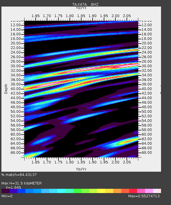
K47A Vremontville, MI, USA - Earthquake Result Viewer
| Earthquake location: |
Central Chile |
| Earthquake latitude/longitude: |
-28.1/-70.7 |
| Earthquake time(UTC): |
2013/01/30 (030) 20:15:43 GMT |
| Earthquake Depth: |
45 km |
| Earthquake Magnitude: |
6.5 MB, 6.5 MS, 6.8 MW, 6.8 MW |
| Earthquake Catalog/Contributor: |
WHDF/NEIC |
|
| Network: |
TA USArray Transportable Network (new EarthScope stations) |
| Station: |
K47A Vremontville, MI, USA |
| Lat/Lon: |
42.67 N/85.00 W |
| Elevation: |
275 m |
|
| Distance: |
71.6 deg |
| Az: |
348.899 deg |
| Baz: |
166.665 deg |
| Ray Param: |
0.054106854 |
| Estimated Moho Depth: |
31.5 km |
| Estimated Crust Vp/Vs: |
1.85 |
| Assumed Crust Vp: |
6.483 km/s |
| Estimated Crust Vs: |
3.514 km/s |
| Estimated Crust Poisson's Ratio: |
0.29 |
|
| Radial Match: |
94.43137 % |
| Radial Bump: |
328 |
| Transverse Match: |
83.40384 % |
| Transverse Bump: |
400 |
| SOD ConfigId: |
494114 |
| Insert Time: |
2013-04-27 04:16:18.300 +0000 |
| GWidth: |
2.5 |
| Max Bumps: |
400 |
| Tol: |
0.001 |
|

Signal To Noise
| Channel | StoN | STA | LTA |
| TA:K47A: :BHZ:20130130T20:26:29.374973Z | 23.752052 | 6.8567506E-6 | 2.8868033E-7 |
| TA:K47A: :BHN:20130130T20:26:29.374973Z | 14.594744 | 3.0094454E-6 | 2.0620062E-7 |
| TA:K47A: :BHE:20130130T20:26:29.374973Z | 2.7846942 | 7.772928E-7 | 2.791304E-7 |
| Arrivals |
| Ps | 4.3 SECOND |
| PpPs | 13 SECOND |
| PsPs/PpSs | 18 SECOND |


